
Manor of St. George
The Manor of St. George (or Georges) occupied nearly all of modern Brookhaven Town from the Carman’s River eastward to the Town of Southampton, and from the Atlantic Ocean to the middle of the island, an area I estimate to be about 90 square miles. Also included was a noncontiguous estate on the north shore at Setauket, which was the early seat of the Manor. The original patent for the Manor of St. George was granted by Gov. Fletcher of New York to Colonel William “Tangier” Smith in 1693. An additional patent was granted in 1697 annexing a large tract of land on the east.
Included within the bounds of the patents was a small parcel on the western side of the Carman’s River (then known as the Connecticut River) called Yamphank Neck. However, a deed five years earlier recorded the sale of the Neck to a Town freeholder, Samuel Terrill; and the Town apparently always considered the parcel within the Town governmental jurisdiction. This area included much of what we now call the Hamlet of South Haven. For 200 years there were legal disputes over the parcel. The Neck theoretically remained under the jurisdiction of the Lord of the Manor until Town jurisdiction was formalized in 1789 when the newly independent government annexed the Manor to the Town and the Manoria prerogatives ended. In Colonial times, the Manor was an important influence in the Town of Brookhaven and all of eastern Long Island; and it is mentioned several times in these pages and in the Hamlet People genealogies.
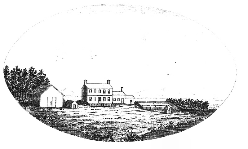
This drawing of the northerly Manor House at Setauket of the Manor of St. George is from Smith and Brainbridge’s The Tangier Smith Family.
Originally from
The New-York Magazine, October 1792
(original caption: Seat of the Honorable Selah Strong, Esq., St. George’s Manor, Suffolk County, Long Island)
♦ 1956 aerial picture of the Manor House at Mastic..
♦ View of Brookhaven Hamlet from the Manor House site at Mastic.
♦ The Manors in New York, published by the New York Genealogical and Biographical Society
When the colony of New York came under rule of the British Crown, an attempt was made to get away from the more democratic forms of local government established under the settlements of the New England colonies and eastern Long Island. The previous presence of large landholders under Dutch rule and the increasing number of persons of wealth and “good” family coming to the already thriving colony set the stage for the introduction of a class of landed gentry such as existed in England. Those colonists with extensive land holdings were therefore allowed of obtain a patent for a manorial Lordship, if they so desired, with local autonomy to collect taxes, and to be exempt from the authority of the local town governments—and many were also given authority to hold “court leet and court baron” over the tenants.
A total of 23 manorial grants were made—21 of them within the present state of New York, and one each in Massachusetts and Rhode Island. The largest was over 1 million acres in present-day Albany, Rensselaer and Columbia counties; the smallest was about 300 acres. The 3300 acre Gardiner’s Island off the eastern tip of Long Island is the only manor in New York still owned entirely by descendants of the original grantee – David Lord Gardiner.
The experiment was not a success. New colonists, instead of flocking to become manorial tenants of the Lord’s lands, went instead to surrounding areas where they could easily become owners of their own lands and be their own masters. The manors survived by granting long leases or by selling off parcels outright. Moreover, many manors were not entailed and so were broken up by inheritance.
The Manor of St. George and Patent of 1697
With the help and advice of New York Gov. Dongan, Col. William Smith began to acquire land in southeastern Brookhaven Town in 1688. In May of 1691 a tract of land eastward from the Connecticut (Carman’s) River to the Mastic (Forge) River was purchased from the Indian, John Mayhew. A patent for this land was granted by New York Gov. Fletcher on Oct. 9, 1693. This included the beachfront from Huntington East Gut (Old Inlet) to “Cuptwauge” (Cupsogue) at the Southampton Town line. This included the islands near the beach. This property ran north to what today is Middle Country Road (NYS Rt. 25). These lands were confirmed under the title of St. George’s Manor.
On May 14, 1691 Colonel William Smith bought from the native, John Mayhew, much of the land east of the Mastic River (Forge River) to the Southampton line (Eastport) except the two necks, “being Meritces (Moriches) and Mamanok Necks, lying together.” Colonel Smith received a patent from Gov. Fletcher on 17 June 1697 for this land, which was annexed to the original St. Georges Manor. (A patent for the much smaller tract that remained separate was granted to Richard Smith, son of Richard Smith “Bull” the patentee of Smithtown, NY, on 17 Nov 1697, and came to be known as the Moriches Patent or Moriches Patentship.) Col. Smith managed to hold but a small portion of his land against the claims of settlers already living within this area, some of whom had deeds from the natives.
The total lands in Colonel Smith’s manor and associated patents comprised an area approximately 64,000 acres, roughly 40% of the land area of the present Town of Brookhaven.
These two patents, with but a few exceptions, meant that Colonel Smith essentially owned all the southeastern portion of the Town of Brookhaven from the Connecticut (Carmans) River east to the Town of Southampton, and from the Atlantic Ocean north to midway across Long Island (to Middle Country Rd.).
In addition, Colonel Smith held non-contiguous lands on Strongs Neck at Setauket, on the north shore. The drawing on this page was of the Manor House at this site—the older of the Manor houses and the original “seat” of the proprietorship. Family convention referred to the northern estate as “St. Georges Manor” and the southern tract as “the Manor of St. George”. The present St. George’s Manor House in Setauket was extensively rebuilt in 1844 to replace the manor house that was there during the Revolutionary War.
The original Manor lands did not long survive intact. On the death of Colonel Smith “Tangier” in 1705, the Setauket estate was inherited by Colonel Henry Smith, William “Tangier” Smith’s eldest surviving son. The Mastic estate was inherited by Major William Henry Smith, the next eldest surviving son. This division of property suggests that the Setauket property was considered the more valuable in spite of the vastness of the Mastic lands. There was a third surviving son, Charles Jeffrey, who may have received some property—I have not researched this. (Charles Jeffrey died unmarried of small pox on 23 May 1715 at the Setauket manor house.)
The Setauket property by the end of the 18th century, was owned by Selah Strong. I have not researched this evolution.
On the death of Major William Henry Smith in 1743, his eldest surviving son, Judge William Smith, inherited the Mastic estate. After the Revolution, Judge Smith divided the his estate among his sons—his eldest son John “The General” was given most of the still remaining Mastic section, and his second son, William was given a smaller estate “Longwood” in the northern part of Yaphank (see map). Much of the Longwood estate remained intact in the Smith family until 1968, and in 1974 the estate house and 35 acres became the property of the Town of Brookhaven as a museum and park (see Longwood for a much more comprehensive history).
On the large southern tract, a Manor House was built on Mastic Neck (now sometimes called Smith’s Point) overlooking the east end of the Great South Bay. There is some controversy as to when the first manor house was built at the south—some say 1690 while others say about 1709. I’m inclined to believe that it was the latter date, which would have been shortly after Col. William “Tangier” Smith’s death in 1705 and the southern tracts came into the possession of his son, Major William Henry Smith. It would have been then that there was the need of another manor house; up until that time the family was well ensconced in Setauket.
During the Revolutionary War the British confiscated the Manor House and erected a small fort. The location was well suited to protect the eastern end of the Great South Bay and the inlet from the Atlantic Ocean that then existed there. The Fort and Manor were destroyed by Major Benjamin Tallmadge and his dismounted dragoons when they attacked Fort St. George in 1780 and returned to Connecticut with the captured British soldiers. The Manor house was rebuilt after the war. Family legend has it that there were three generations of manor houses—the original house, the house destroyed during the Revolutionary War, and the present house. The original house was said to have been built about 100-125 feet from the present house. It is also said that the present house incorporates parts of the original house—however, I think this unlikely. It is hard for me to imagine that any useable portion of the Revolutionary War era structures could have remained after being torched by Major Tallmadge. As far as I know, there have been no archeological studies or records research which would suggest otherwise.
Some of Colonel “Tangier” Smith’s original land therefore also remains intact as the Manor of St. George at Mastic, with its buildings and 127 acres. It is now also a public museum and park. The Manor House and grounds were given to the people of Brookhaven Town and the public at large in 1955 by Eugenie Annie Tangier Smith. The grounds are accessible from the William Floyd Parkway in Shirley.
The Manor of St. George remained an independent political jurisdiction until after the Revolutionary War, when, by act of the newly independent New York State legislature in 1789, it was formally annexed to the Town of Brookhaven. At that time, the Lord’s manorial prerogatives ceased, although the Lord’s property rights remained. The “Lords” of the manor continued to be prominent in the affairs of the Town.
Fire Place Connections: Colonel William “Tangier” Smith’s granddaughter, Gloryana Smith, married Justice Nathaniel Brewster (ii), a large land owner in Fire Place and Occumbomock (Bellport). And his great-great-grandson William (5th “Lord” of the Manor) married Hannah Carman, daughter of Samuel Carman, Sr., of Fire Place/South Haven. (It is said that William, who claimed ownership and control of the river then called Connecticut, had it renamed Carman’s River in honor of his wife.) There may have been other “Fire Place” connections not yet identified—Fire Place being the “poorer” community on the other side of the river.
Floyd Estate
In about 1718, some 4000 acres of the Manor in eastern Mastic Neck was acquired by Richard Floyd, who gave it to his son Nicoll, who built the original estate house in 1724. He cleared and planted the lands and made it into a prosperous plantation. He and his wife had nine children and in 1755 both died of typhoid fever.
The large estate and responsibility for the younger children fell to the twenty year old eldest son, William, who was a signer of the Declaration of Independence. William was born on the estate in 1734, the first of the Floyds to be born there. He was the first President of the South Haven Presbyterian Church’s Board of Trustees. As Long Island was under British control during the Revolutionary War, the Floyd family had to flee to Connecticut. William Floyd’s descendent, Mary Gelston Floyd, married John Lawrence Ireland of Fire Place. William Floyd and family moved to Westernville, Oneida County, NY in the early 19th century.
The mansion house and 35 acres of land are all that remain of the original Floyd estate. They are maintained by the National Park Service.