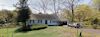
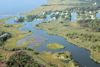
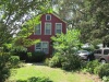
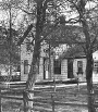
| Br01 |
Brookhaven Hamlet District |
|
Historic and Natural Districts Inventory Form |
2011-11-25 |
 |
 |
 |
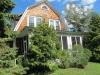
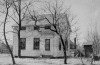
| Br01.1 |
Fire Place Manse or Parsonage Lands |
Brookhaven,NY |
Archeological Site Inventory Form |
2015-09-14 |
 |
 |
|
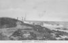
| Br01.1.1-S |
Fire Place Boat Basin (Gould's Marina) |
Foot of Fire Place Ln. on Beaver Dam Creek |
Historic and Natural Districts Inventory Form |
2011-01-17 |
 |
|
|
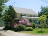
| Br01.1.2-S |
South Country Road |
South Country Rd., Brookhaven, NY |
Historic and Natural Districts Inventory Form |
2015-10-24 |
 |
|
|
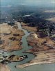
| Br01.1-S |
Beaver Dam Creek |
|
Historic and Natural Districts Inventory Form |
2003-07-21 |
 |
|
|
| Br01.2-S |
Tar-men's Neck |
|
Archeological Site Inventory Form |
2011-10-22 |
|
|
|
| Br01.3.1-S |
Robert & Mary Lyons House |
Arthur Ave (aka Cemetery Rd.) Brookhaven, NY |
Archeological Site Inventory Form |
2014-07-02 |
 |
|
|
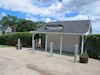
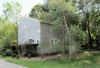
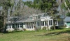
| Br01.3.2-S |
Varney's Restaurant |
2109 Montauk Hwy, Brookhaven, NY |
Building-Structure Inventory Form |
2020-12-05 |
_thumb.jpg) |
|
|
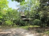
| Br01.3-S |
Oaklawn Cemetery |
North End of Arthur Ave., off Montauk Hwy. |
Historic and Natural Districts Inventory Form |
2011-08-11 |
|
|
|
| Br01.4-S |
Brookhaven Fire District/Brookhaven Fire Department |
|
Historic and Natural Districts Inventory Form |
2010-11-17 |
|
|
|
| Br01.6-S |
Fire Place & Old Inlet Beach Clubs |
Fire Island |
Archeological Site Inventory Form |
2011-05-28 |
 |
|
|
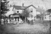
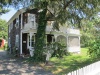
| Br02 |
Nathaniel Hawkins Cemetery |
Montauk Highway near corner Old Stump. Rd. |
Historic and Natural Districts Inventory Form |
2007-07-05 |
_thumb.jpg) |
|
|
| Br02.0-S |
Snow's Corner |
Montauk Highway and Yaphank Avenue (Old Stump Road) |
Historic and Natural Districts Inventory Form |
2010-01-31 |
|
|
|
| Br02.1-S |
Brookhaven Railroad Station |
Railroad Ave. at Old Stump Rd. |
Archeological Site Inventory Form |
2004-03-26 |
 |
|
|
| Br03 |
Site of Hawkins house & Farm |
West side, Little Neck |
Archeological Site Inventory Form |
2007-07-04 |
 |
|
|
| Br03.1-S |
Site of Barteau Farm |
Little Neck, Brookhaven, NY |
Archeological Site Inventory Form |
2007-07-02 |
 |
|
|
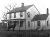
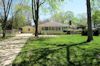
| Br04 |
Andrew Gildersleeve - Riker house |
2527 Montauk Highway |
Building-Structure Inventory Form |
2012-06-22 |
 |
|
|
| Br04.1.1-S |
Barteau Cemetery |
Montauk Highway |
Historic and Natural Districts Inventory Form |
2011-06-22 |
 |
|
|
| Br04.1-S |
Old Barteau House |
2635 Montauk Highway |
Building-Structure Inventory Form |
2010-05-03 |
 |
|
|
| Br04.2.1-S |
Tiger Nursery Sales Office |
2565 Montauk Hwy |
Archeological Site Inventory Form |
2009-06-12 |
 |
|
|
| Br04.2-S |
Cedar Inn (and sucessors) |
2647 Montauk Highway |
Building-Structure Inventory Form |
2015-10-23 |
 |
|
|
| Br04.3-S |
Tice's - Howie's - Sue's Haven |
Montauk Hwy., e/o Fire House |
Archeological Site Inventory Form |
2011-01-14 |
 |
|
|
| Br04.4-S |
Ghosio Vegatable Stand |
Montauk Highway |
Archeological Site Inventory Form |
2008-08-19 |
 |
|
|
| Br04.5-S |
Waldron's Brookhaven Garage |
2448 Montauk Hwy |
Building-Structure Inventory Form |
2009-10-31 |
 |
|
|
| Br04.6-S |
Robins' Inn |
South Country Rd. @ Montauk Highway |
Building-Structure Inventory Form |
2010-01-30 |
|
|
|
| Br04A |
Kosenkranius Gas Station |
E/S South Country Rd. at Bridge St. |
Building-Structure Inventory Form |
2009-12-26 |
 |
|
|
| Br04A.1-S |
Better 'Ole Restaurant |
416 South Country Rd. (at RR Viaduct) |
Building-Structure Inventory Form |
2012-05-02 |
 |
|
|
| Br04A.2-S |
Original Site Brookhaven Fire Department |
Northwest corner, Bridge and Seeley Street |
Archeological Site Inventory Form |
2009-02-19 |
 |
|
|
| Br05 |
N. Corwin - McEnery House |
414 S. Country Road |
Building-Structure Inventory Form |
2010-04-12 |
 |
|
|
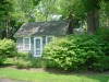
| Br05A |
[Bancroft House] "Blue Shutters" (aka Gilligan House ) |
12 Trout Pond Court |
Building-Structure Inventory Form |
2012-01-19 |
 |
|
|
| Br05B |
Richard Corwin - Carl Olson house ["Willow Tree Cottage"] |
408 South Country Road |
Building-Structure Inventory Form |
2011-08-31 |
 |
|
|
| Br05B.1-S |
Corwin Private Cemetery |
Between Chapel and Beaverbrook Drive |
Historic and Natural Districts Inventory Form |
2005-11-26 |
|
|
|
| Br05C |
Chapel house |
1 Chapel Avenue |
Building-Structure Inventory Form |
2013-04-16 |
 |
|
|
| Br05D |
Site of fish house |
Beaver Dam Creek |
Archeological Site Inventory Form |
1982-09-03 |
 |
|
|
| Br05D.1-S |
Ellison House |
South Country Rd. |
Archeological Site Inventory Form |
2003-06-30 |
 |
|
|
| Br06 |
Brook House (former restaurant) |
405 South Country Road |
Building-Structure Inventory Form |
2009-06-16 |
 |
|
|
| Br06A |
Ketcham-Nelson house "Middlebrook" |
388 South Country Road |
Building-Structure Inventory Form |
2010-04-01 |
 |
|
|
| Br06A.1-S |
Valentine's Corner (Memorial & Fire Place Parks) |
South Country Rd. and Fire Place Neck Rd. |
Historic and Natural Districts Inventory Form |
2015-06-06 |
 |
|
|
| Br06A.2-S |
Former Ketcham Private Graveyard |
abt 368 South Country Rd. |
Archeological Site Inventory Form |
2005-11-26 |
|
|
|
| Br07 |
Old Brook Store |
378 South Country Road |
Building-Structure Inventory Form |
2010-09-16 |
 |
|
|
| Br07.0-S |
Gerard House (now destroyed) |
N/S South Country Rd. west of Beaver Dam Creek |
Archeological Site Inventory Form |
2008-10-02 |
 |
|
|
| Br07.1-S |
Barteau House (now destroyed) |
South Country Road at Andiron Lane |
Archeological Site Inventory Form |
2011-08-25 |
 |
|
|
| Br07.2-S |
Andrews Farm |
w/s Beaver Dam Creek from S. Country Rd to RR. |
Archeological Site Inventory Form |
2005-11-30 |
 |
|
|
| Br07.3-S |
Old [1902] Presbyterian Church Manse |
366 South Country Rd. |
Building-Structure Inventory Form |
2015-02-09 |
 |
|
|
| Br07A-S |
W. S. Hawkins House (now destroyed) |
s/s South Country Road, w/o Beaver Dam Creek |
Archeological Site Inventory Form |
2015-02-11 |
 |
|
|
| Br08 |
Smith house [Fire Place Inn] |
359 South Country Road |
Building-Structure Inventory Form |
2015-11-11 |
 |
|
|
| Br08.1-S |
Forrest Reeve House |
349 South Country Rd. |
Building-Structure Inventory Form |
2009-04-15 |
 |
|
|
| Br09 |
H. Raynor house |
South Country Rd. |
Building-Structure Inventory Form |
2008-10-20 |
 |
|
|
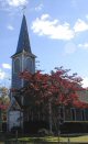
| Br09A |
Old South Haven Presbyterian Church |
329 South Country Road at Beaver Dam Road |
Building-Structure Inventory Form |
2014-12-24 |
 |
|
|
| Br09B |
Post house - "The Homestead" |
abt 323-325 South Country Road |
Building-Structure Inventory Form |
2015-11-09 |
 |
|
|
| Br09B.1-S |
Post Carriage House |
Beaver Dam Rd. at South Country Rd. |
Building-Structure Inventory Form |
2011-06-20 |
 |
|
|
| Br09B.2-S |
Post Chauffeur's Cottage - Anderson/Kerins House |
186 Beaver Dam Rd |
Building-Structure Inventory Form |
2009-02-28 |
 |
|
|
| Br09B.3-S |
Post Cottage "Post Script" |
South Country Road |
Building-Structure Inventory Form |
2008-10-20 |
 |
|
|
| Br09C |
Isaac Seaman house |
South Country Road |
Building-Structure Inventory Form |
2011-12-23 |
 |
|
|
| Br09C.1-S |
Betsey Rowland Burial Site |
South Country Rd. |
Historic and Natural Districts Inventory Form |
2005-11-15 |
|
|
|
| Br09C.2-S |
Beaver Dam Boat Basin |
320 South Country Road |
Building-Structure Inventory Form |
2011-12-23 |
 |
|
|
| Br09D |
Seaman-Ljungvist house |
South Country Road |
Building-Structure Inventory Form |
2011-12-23 |
 |
|
|
| Br09D.1-S |
Deer Run Farms |
282 South Country Rd. |
Historic and Natural Districts Inventory Form |
2012-06-24 |
 |
|
|
| Br09E |
Carol Robinson cottage |
South Country Road |
Building-Structure Inventory Form |
2012-06-24 |
 |
|
|
| Br09F |
Mills Clark-Rose house |
South Country Road |
Building-Structure Inventory Form |
1975-03-10 |
 |
|
|
| Br09F.1-S |
Holy Trinity Holiday House |
315 South Country Rd. (modern address) |
Archeological Site Inventory Form |
2011-06-20 |
 |
|
|
| Br10 |
Hubert house "Whynot" |
303 South Country Road |
Building-Structure Inventory Form |
2011-12-05 |
 |
|
|
| Br10.00-S |
Hubert Lane and Estate |
303 South Country Road |
Historic and Natural Districts Inventory Form |
2011-06-21 |
|
|
|
| Br10.01-S |
Hubert Barn/Guest House "Barnstead" |
Hubert Lane (303 S. Country Rd.) |
Building-Structure Inventory Form |
No Datasheet |
|
|
|
| Br10.11-S |
Washington Lodge |
about 269-287 South Country Road |
Building-Structure Inventory Form |
2016-08-26 |
 |
|
|
| Br10.12-S |
George Washington Factory Workers Houses |
144-148 Beaver Dam Rd. |
Building-Structure Inventory Form |
2010-09-14 |
 |
|
|
| Br10A |
Brown house |
259 South Country Road |
Building-Structure Inventory Form |
1982-07-26 |
|
|
|
| Br11 |
J. Smith-Kouts house |
249 South Country Road |
Building-Structure Inventory Form |
2011-05-01 |
 |
|
|
| Br12 |
Fletcher-Scwartz house |
245 South Country Road |
Building-Structure Inventory Form |
1982-07-26 |
 |
|
|
| Br13 |
J. Ryder House |
234 South Country Road |
Building-Structure Inventory Form |
1982-07-26 |
 |
|
|
| Br14 |
Hawkins-Miller house |
237 South Country Road |
Building-Structure Inventory Form |
1982-07-26 |
 |
|
|
| Br15 |
Woodruff-Miller house |
South Country Road |
Building-Structure Inventory Form |
1982-07-26 |
|
|
|
| Br15.1-S |
Woodruff Private Cemetery |
n/s South Country Rd. east of Bellport Village line. |
Historic and Natural Districts Inventory Form |
2005-11-26 |
|
|
|
| Br15.2-S |
Dayton's Neck |
S. Country Road, west Fire Place |
Historic and Natural Districts Inventory Form |
2012-06-28 |
|
|
|
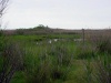
| Br15.3-S |
Dennis Puleston Nature Preserve |
South Country Road |
Historic and Natural Districts Inventory Form |
2014-11-30 |
|
|
|
| Br16 |
Squassux Landing |
About 372-374 Beaver Dam Road |
Historic and Natural Districts Inventory Form |
2010-11-07 |
 |
|
|
| Br16.0-S |
Beaver Dam Road |
|
Historic and Natural Districts Inventory Form |
2011-08-25 |
 |
|
|
| Br16.1.0-S |
Newey-Tooker Boat Yard |
22 Newey Lane |
Building-Structure Inventory Form |
2011-06-21 |
 |
|
|
| Br16.1.1-S |
20 Newey Lane |
20 Newey Lane |
South Shore Estuary Survey Form |
2011-03-29 |
 |
|
|
| Br16.1.2-S |
Charles Newey House |
14 Newey Lane |
South Shore Estuary Survey Form |
2011-08-22 |
 |
|
|
| Br16.1.3-S |
9 Newey Lane |
9 Newey Lane |
Building-Structure Inventory Form |
No Datasheet |
 |
|
|
| Br16.1.5-S |
Murdock-Grodeski House |
5 Newey Lane |
South Shore Estuary Survey Form |
2011-08-23 |
 |
|
|
| Br16.1.6-S |
Ebenezer Albin House |
3 Newey Lane |
South Shore Estuary Survey Form |
2010-12-23 |
 |
|
|
| Br16.1.7-S |
2 Newey Lane |
2 Newey Lane |
Building-Structure Inventory Form |
No Datasheet |
 |
|
|
| Br16.2-S |
Joseph Carman / Carman Lush House (now destroyed) |
N/S Beaver Dam Rd. at Carman's River |
Archeological Site Inventory Form |
2011-11-23 |
 |
|
|
| Br16.3-S |
F. A. Smith House |
365 Beaver Dam Rd. |
Building-Structure Inventory Form |
No Datasheet |
 |
|
|
| Br16.4-S |
A. Gerard House (now destroyed) |
northeast corner Beaver Dam Rd. and Old Stump Rd. |
Archeological Site Inventory Form |
2005-12-07 |
 |
|
|
| Br16.5-S |
Barry-Leger House |
nw Corner Beaver Dam & Old Stump Rds. |
Archeological Site Inventory Form |
No Datasheet |
 |
|
|
| Br16.6-S |
C. Darling House |
355 Beaver Dam Rd. |
Building-Structure Inventory Form |
2015-02-23 |
 |
|
|
| Br16.7-S |
"Fireplace Farm" [Moved Section] |
358 Beaver Dam Rd. |
Building-Structure Inventory Form |
No Datasheet |
 |
|
|
| Br17 |
"Fireplace Farm" [Ezra King house] |
352 Beaver Dam Road |
Building-Structure Inventory Form |
2013-09-06 |
 |
|
|
| Br17.1.1-S |
Munhofen House |
349 Beaver Dam Road |
Building-Structure Inventory Form |
2015-12-09 |
 |
|
|
| Br17.1-S |
John Smith Rose House - Edgewater Inn |
349 Beaver Dam Rd. |
Archeological Site Inventory Form |
2010-10-21 |
 |
|
|
| Br17.2-S |
S. Barteau house |
N.S. Beaver Dam Rd., east of Br17.1-S |
Archeological Site Inventory Form |
No Datasheet |
|
|
|
| Br17A |
Brewster Rose-Tuthill house |
339 Beaver Dam Road |
Building-Structure Inventory Form |
2008-03-04 |
 |
|
|
| Br17A.1-S |
Ince Cottage |
344 Beaver Dam Rd. |
Building-Structure Inventory Form |
No Datasheet |
 |
|
|
| Br17A.2-S |
Booth House |
abt 344 Beaver Dam Rd. |
Archeological Site Inventory Form |
2010-12-22 |
|
|
|
| Br18 |
Nelson house [Albin Store] |
340 Beaver Dam Road |
Building-Structure Inventory Form |
2011-08-09 |
 |
|
|
| Br18.1-S |
Danto House |
338 Beaver Dam Rd. |
Building-Structure Inventory Form |
2008-03-03 |
 |
|
|
| Br18.2-S |
Haskell-Phillips House |
334 Beaver Dam Rd. |
Building-Structure Inventory Form |
2008-03-20 |
 |
|
|
| Br18A |
Swezey-Wiswall house |
331 Beaver Dam Road |
Building-Structure Inventory Form |
2015-11-10 |
 |
|
|
| Br18B |
Burnett Farm and Homestead (modern Rowley house) |
325 Beaver Dam Road |
Building-Structure Inventory Form |
2012-05-08 |
 |
|
|
| Br18B.1-S |
George Bishop Cottage II |
324 Beaver Dam Rd @ Burnett Lane |
Building-Structure Inventory Form |
2011-07-27 |
 |
|
|
| Br18B.2-S |
Albin-Bishop House |
6 Burnett Lane |
South Shore Estuary Survey Form |
2004-06-30 |
 |
|
|
| Br18B.3-S |
George Bishop House I |
324 Beaver Dam Rd. @ Burnett Ln |
Archeological Site Inventory Form |
2011-07-25 |
|
|
|
| Br18B.4-S |
Burnett Farm South (including old Barn now destroyed) |
Beaver Dam Rd. @ Burnett Ln. |
Archeological Site Inventory Form |
2012-05-04 |
|
|
|
| Br19 |
Everest house |
318 Beaver Dam Road |
Building-Structure Inventory Form |
2015-11-11 |
 |
|
|
| Br19.1-S |
Burnett Barn ("Red Barn" - Now Destroyed) |
Abt. 321 Beaver Dam Rd. |
Building-Structure Inventory Form |
2012-05-05 |
 |
|
|
| Br20 |
Selah [Herman] Hawkins house |
311 Beaver Dam Road |
Building-Structure Inventory Form |
2013-09-06 |
 |
|
|
| Br20.1-S |
Jesse Rose - Selah Hawkins Hawkins House |
Abt 305 Beaver Dam Rd |
Archeological Site Inventory Form |
2008-03-16 |
|
|
|
| Br21 |
Charles Newey [Hotcaveg, Hudis] house |
312/14 Beaver Dam Road |
Building-Structure Inventory Form |
2013-09-06 |
 |
|
|
| Br22 |
[Henry Egbert] Hawkins-Watson house |
310 Beaver Dam Road |
Building-Structure Inventory Form |
2009-01-17 |
 |
|
|
| Br23 |
[Selah] Hawkins-Osterhout house |
306 Beaver Dam Road |
Building-Structure Inventory Form |
2008-03-18 |
 |
|
|
| Br23.000-S |
Hawkins lane |
Hawkins lane |
Historic and Natural Districts Inventory Form |
No Datasheet |
|
|
|
| Br23.015-S |
Rose-Koop House |
15 Hawkins Ln |
Building-Structure Inventory Form |
2011-08-14 |
 |
|
|
| Br23.051-S |
51 Hawkins Lane |
51 Hawkins Lane |
Building-Structure Inventory Form |
2015-11-23 |
 |
|
|
| Br23A.000-S |
Wallace Lane |
Wallace Lane |
Historic and Natural Districts Inventory Form |
2011-08-08 |
|
|
|
| Br23A.005-S |
Keene House (Sleepy Hollow Farm) |
5 Wallace Ln (formerly 5 Hawkins Ln) |
Building-Structure Inventory Form |
2011-08-08 |
 |
|
|
| Br23B.000-S |
Rose Ln |
Rose Ln |
Historic and Natural Districts Inventory Form |
2011-08-12 |
|
|
|
| Br23B.001-S |
Learned-Wagner House "Valhalla" |
Rose Ln, off Hawkins Ln |
Building-Structure Inventory Form |
2008-10-03 |
 |
|
|
| Br24 |
Nelson-Andors house |
304 Beaver Dam Road |
Building-Structure Inventory Form |
2015-11-11 |
 |
|
|
| Br24A |
Furst-Brown house |
301 Beaver Dam Road |
Building-Structure Inventory Form |
2009-01-04 |
 |
|
|
| Br24A.1-S |
Morse-Huston House "Sunnylands" |
295 Beaver Dam Rd. |
Building-Structure Inventory Form |
2010-07-29 |
 |
|
|
| Br24A.2-S |
Samuel Hawkins - George Barteau house |
abt 291-295 Beaver Dam Rd. |
Archeological Site Inventory Form |
2007-04-08 |
 |
|
|
| Br24A.3-S |
Ewing House |
291 Beaver Dam Rd. |
Building-Structure Inventory Form |
2008-10-05 |
 |
|
|
| Br24B |
[Deacon Daniel] Hawkins-Johanknect house |
298 Beaver Dam Road |
Building-Structure Inventory Form |
2006-10-20 |
 |
|
|
| Br24B.1-S |
Alburger Pond, a.k.a. Deacon Daniel Hawkins Pond & Frederick Kost Pond |
Beaver Dam Road |
Historic and Natural Districts Inventory Form |
2015-11-14 |
 |
|
|
| Br24B.2-S |
Albuger House |
290 Beaver Dam Road |
Archeological Site Inventory Form |
2015-11-14 |
 |
|
|
| Br25 |
Thomas Morrow, Sr. Homestead "Acacia", Sherman House |
abt 285 Beaver Dam Road |
Building-Structure Inventory Form |
2008-10-03 |
 |
|
|
| Br26 |
Miller-Pizzichemi-[Blume] house [The Oaks] |
281 Beaver Dam Road |
Building-Structure Inventory Form |
2014-12-24 |
 |
|
|
| Br26.1-S |
Ireland House |
|
Archeological Site Inventory Form |
2009-08-29 |
 |
|
|
| Br26A |
Scordamaglia House [Corrigan House] |
Beaver Dam Road and Mott Lane |
Building-Structure Inventory Form |
2007-02-26 |
 |
|
|
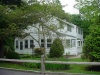
| Br27 |
Brookhaven Free Library |
273 Beaver Dam Road at Library Lane |
Building-Structure Inventory Form |
2011-06-20 |
 |
|
|
| Br27.0-S |
Stillwoods Road |
Stillwoods Road |
Historic and Natural Districts Inventory Form |
2010-02-23 |
|
|
|
| Br27.1-S |
Frank Wilson Barteau House |
269 Beaver Dam Rd. |
South Shore Estuary Survey Form |
2004-06-11 |
 |
|
|
| Br27.2-S |
Ballard House |
267 Beaver Dam Rd. |
Building-Structure Inventory Form |
No Datasheet |
 |
|
|
| Br27A |
Weissmann House [Tiger House] |
270 Beaver Dam Road at Edgar Avenue |
Building-Structure Inventory Form |
2007-04-16 |
 |
|
|
| Br27A.1-S |
The William Rose - Charles Sweezey House |
NE corner Beaver Dam & Fire Place Neck Rd. |
Archeological Site Inventory Form |
2003-06-22 |
 |
|
|
| Br28 |
Gwynne [Nehemiah Hulse] house |
255 Beaver Dam Road corner Fireplace Neck Road |
Building-Structure Inventory Form |
2015-02-12 |
 |
|
|
| Br28A |
St. James Episcopal Church |
260 Beaver Dam Road at Bay Road |
Building-Structure Inventory Form |
2011-06-21 |
 |
|
|
| Br28A.1 |
St. James Parsonage |
260 Beaver Dam Road |
South Shore Estuary Survey Form |
2013-08-12 |
 |
|
|
| Br29 |
Fraser-Champlain house |
249 Beaver Dam Road |
Building-Structure Inventory Form |
2007-06-21 |
 |
|
|
| Br29.1-S |
Champlain/Tooker Cottage |
Beaver Dam Rd @ Beaver Dam Creek |
Building-Structure Inventory Form |
2010-10-21 |
 |
|
|
| Br29.2-S |
Post Park |
n/s Beaver Dam road w/s Beaver Dam creek |
Historic and Natural Districts Inventory Form |
2013-09-18 |
 |
|
|
| Br29A |
Badetty-Reddall-Petretti house |
252 Beaver Dam Road at Bay Road (west corner) |
Building-Structure Inventory Form |
2009-11-16 |
 |
|
|
| Br29B |
Rose-Lyons house |
Beaver Dam Road |
Building-Structure Inventory Form |
2005-12-16 |
 |
|
|
| Br29B.1-S |
Greenfield Burial Site |
east of 338 South Country Rd. |
Archeological Site Inventory Form |
No Datasheet |
|
|
|
| Br29B.2-S |
228 Beaver Dam Rd. |
228 Beaver Dam Rd. |
Building-Structure Inventory Form |
No Datasheet |
 |
|
|
| Br29C |
Old Methodist Church - [Read, Morley residences] |
224 Beaver Dam Road |
Building-Structure Inventory Form |
2014-09-05 |
 |
|
|
| Br30 |
Wellington house "The Meadows" |
end of Meadow Lane |
Building-Structure Inventory Form |
2008-10-03 |
 |
|
|
| Br30.00-S |
Meadow Lane |
|
Historic and Natural Districts Inventory Form |
2008-10-08 |
|
|
|
| Br30.1-S |
Ryder Burial Site |
East of Meadow Lane. North side of Puleston-Clement Farm |
Historic and Natural Districts Inventory Form |
No Datasheet |
|
|
|
| Br30.2-S |
Gardner Rea House |
12 Meadow Lane |
Building-Structure Inventory Form |
2015-11-11 |
 |
|
|
| Br30A |
Long Point, site of Indian kiln |
|
Archeological Site Inventory Form |
2007-12-24 |
|
|
|
| Br30B |
Valentine-Jenson house |
3 Fireplace Neck Road |
Building-Structure Inventory Form |
2009-12-01 |
 |
|
|
| Br30C |
Miller House and Farm (Allardt/Geraghty house) |
9 Fireplace Neck Road |
Building-Structure Inventory Form |
2015-08-14 |
 |
|
|
| Br30C.1-S |
Miller Family Cemetery |
Fireplace Neck Rd. |
Historic and Natural Districts Inventory Form |
No Datasheet |
|
|
|
| Br31 |
Brookhaven Elementary School [1927 wing] |
Fireplace Neck Road |
Building-Structure Inventory Form |
1982-09-09 |
 |
|
|
| Br31.1-S |
Old 1873 Brookhaven School |
Fire Place Neck Rd. |
Building-Structure Inventory Form |
2010-10-31 |
 |
|
|
| Br31A |
Hulse Cemetery |
Fireplace Neck Road |
Historic and Natural Districts Inventory Form |
No Datasheet |
 |
|
|
| Br32 |
Breckenridge house |
32 Fireplace Neck Road |
Building-Structure Inventory Form |
1982-09-09 |
 |
|
|
| Br32A |
Swezey-DeHond house |
5 Locust Lane |
Building-Structure Inventory Form |
2011-01-06 |
 |
|
|
| Br32A.13-S |
Corwin/Bishop/Cox Cottage |
13 Locust road |
South Shore Estuary Survey Form |
2015-06-05 |
 |
|
|
| Br32A.1-S |
Richard Corwin & Chauncey Swezey House |
12 Locust Rd. |
Building-Structure Inventory Form |
2011-09-10 |
 |
|
|
| Br33 |
Rose Cemetery |
Jareds Path |
Historic and Natural Districts Inventory Form |
1982-08-16 |
 |
|
|
| Br33.1-S |
Mott Family Cemetery |
e/s Mott Lane, s/o Bond Lane |
Historic and Natural Districts Inventory Form |
2005-08-29 |
|
|
|
| Br34 |
Azel Hawkins Cemetery [a.k.a. Deacon Daniel Hawkins Cemetery] |
Stillwoods Road |
Historic and Natural Districts Inventory Form |
1982-08-16 |
 |
|
|
| Br35 |
Lighthouse [Brookhaven Shores Sales Office] |
Lindner Court |
Building-Structure Inventory Form |
2015-11-29 |
 |
|
|
| Br35.1-S |
Beaver Dam Creek Lighthouse |
12 Lindner Court |
Building-Structure Inventory Form |
2015-11-28 |
 |
|
|
| Br35A.050-S |
Old Cook Estate Carriage House |
Abt. 50 Bellhaven Rd. |
Building-Structure Inventory Form |
No Datasheet |
|
|
|
| Br35A.060-S |
Old Cook Estate Stables |
60 Bellhaven Rd. |
Building-Structure Inventory Form |
No Datasheet |
|
|
|
| Br35A.078-S |
Cook House |
78 Bellhaven Rd. |
Building-Structure Inventory Form |
No Datasheet |
|
|
|
| Br35A-S |
Bellhaven Rd. |
Bellhaven Rd. |
Historic and Natural Districts Inventory Form |
No Datasheet |
|
|
|
| Br35B-S |
Brookhaven Shores |
Bellhaven Road |
Historic and Natural Districts Inventory Form |
2015-11-28 |
 |
|
|
| Br36.000-S |
Old Stump Road |
|
Historic and Natural Districts Inventory Form |
No Datasheet |
|
|
|
| Br36.105-S |
Leszkowicz Duck Farm |
About 105 Old Stump Road |
Building-Structure Inventory Form |
2011-05-23 |
 |
|
|
| Br36.169-S |
Michelsen House |
169 Old Stump Rd. |
Building-Structure Inventory Form |
2011-08-17 |
 |
|
|
| Br36.170-S |
170 Old Stump Rd. |
170 Old Stump Rd. |
Building-Structure Inventory Form |
2011-08-18 |
 |
|
|
| Br36.174-S |
174 Old Stump Rd. |
174 Old Stump Rd. |
Building-Structure Inventory Form |
2011-08-18 |
 |
|
|
| Br36.175-S |
Wallace Swezey House |
175 Old Stump Rd. |
Building-Structure Inventory Form |
2011-08-17 |
 |
|
|
| Br36.178-S |
178 Old Stump Rd. - Kresse House |
178 Old Stump Rd. |
South Shore Estuary Survey Form |
2010-03-02 |
 |
|
|
| Br36.179A-S |
Conklin Private Cemetery |
Behind 179 Old Stump Rd. |
Historic and Natural Districts Inventory Form |
2011-08-18 |
 |
|
|
| Br36.179-S |
Wallace Halsey Swezey House - 179 Old Stump Rd. |
179 Old Stump Rd. |
South Shore Estuary Survey Form |
2015-11-10 |
 |
|
|
| Br36.181-S |
Edna Bennet cottage |
Edna Bennet cottage |
Building-Structure Inventory Form |
2013-08-13 |
 |
|
|
| Br36.183-S |
Stephen J. Swezey House |
183 Old Stump Rd. |
Building-Structure Inventory Form |
2013-08-10 |
 |
|
|
| Br36.184-S |
184 Old Stump Rd. |
184 Old Stump Rd. |
Building-Structure Inventory Form |
No Datasheet |
|
|
|
| Br36.187-S |
Tom Poole House |
187 Old Stump Rd. |
South Shore Estuary Survey Form |
2011-08-19 |
 |
|
|
| Br36.188-S |
Murdock House |
188 Old Stump Rd. |
Building-Structure Inventory Form |
2011-08-23 |
 |
|
|
| Br36.191-S |
Rossmore (Michelson/Quinn House) |
191 Old Stump Rd. |
Building-Structure Inventory Form |
No Datasheet |
 |
|
|
| Br36.192-S |
Leo Cornell House |
192 Old Stump Rd. |
South Shore Estuary Survey Form |
2011-08-19 |
 |
|
|
| Br37.000-S |
Edgar Avenue |
|
Historic and Natural Districts Inventory Form |
No Datasheet |
 |
|
|
| Br37.01-S |
Stirling-Clevidence House |
South end Edgar Ave. (108 Edgar Ave.) |
Building-Structure Inventory Form |
2009-05-06 |
 |
|
|
| Br38.000-S |
Bay Road |
|
Historic and Natural Districts Inventory Form |
No Datasheet |
 |
|
|
| Br38.012-S |
H.H. Reddall House |
12 Bay Rd. |
Building-Structure Inventory Form |
2009-11-16 |
 |
|
|
| Br38.016-S |
Thomas Morrow Jr. Homestead, "Trepia" |
16 Bay Rd. |
Building-Structure Inventory Form |
2008-10-03 |
 |
|
|
| Br38.065-S |
Duke House |
65 Bay Road |
Building-Structure Inventory Form |
2014-05-11 |
 |
|
|
| Br38.068-S |
August Starke House |
68 Bay Road |
Building-Structure Inventory Form |
2009-10-26 |
 |
|
|
| Br38.150-S |
Charles Starke House - Shore Acres (Fire Place Nature Preserve) |
West side, south end Bay Road |
Archeological Site Inventory Form |
2009-10-23 |
|
|
|
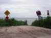
| Br39.000-S |
Ocean Place |
Ocean Place |
Historic and Natural Districts Inventory Form |
2011-08-24 |
 |
|
|
| Br39.015-S |
15 Ocean Place |
15 Ocean Place |
South Shore Estuary Survey Form |
2011-08-26 |
 |
|
|
| Br39.017-S |
17 Ocean Place |
17 Ocean Place |
South Shore Estuary Survey Form |
2011-08-26 |
 |
|
|
| SH01 |
South Haven Hamlet District |
|
Historic and Natural Districts Inventory Form |
2015-07-09 |
 |
|
|
| SH01.1-S |
Carman's (Connecticut) River |
|
Historic and Natural Districts Inventory Form |
2008-02-07 |
 |
|
|
| SH01A |
Wertheim National Wildlife Refuge |
360 Smith Rd.
Shirley, NY 11967 |
Historic and Natural Districts Inventory Form |
2010-10-08 |
 |
|
|
| SH01A.1-S |
David Hawkins Cemetery |
Wertheim National Wildlife Refuge |
Historic and Natural Districts Inventory Form |
2007-07-05 |
|
|
|
| SH02 |
Carmans Mills and Carman Homestead and Tavern |
Montauk Highway |
Archeological Site Inventory Form |
1982-07-14 |
 |
|
|
| SH02.1-S |
Carman and Miller Private Graveyard |
South Haven County Park - Robinson Farm |
Historic and Natural Districts Inventory Form |
2008-04-05 |
 |
|
|
| SH03 |
Southaven Cemetery (Presbyterian Church) |
Montauk Highway |
Historic and Natural Districts Inventory Form |
1982-07-14 |
 |
|
|
| SH04 |
Robinson Duck Farm |
Montauk Highway |
Building-Structure Inventory Form |
2008-07-28 |
 |
|
|
| SH04.1-S |
Howard Robinson Store |
Montauk Hwy |
Building-Structure Inventory Form |
2010-10-20 |
 |
|
|
| SH05 |
Robinson-Miller House |
Montauk Highway |
Building-Structure Inventory Form |
2012-07-06 |
 |
|
|
| SH06 |
D. Wesche - C. Homan house |
2891 Montauk Highway |
Building-Structure Inventory Form |
2005-10-22 |
 |
|
|
| SH07 |
Tobin-S. Homan house |
2875 Montauk Highway |
Building-Structure Inventory Form |
2005-10-22 |
 |
|
|
| SH07.1-S |
Homan Family Cemetery |
Wertheim National Wildlife Refuge |
Archeological Site Inventory Form |
2005-08-28 |
|
|
|
| SH08 |
Robert Carman house |
2847 Montauk Highway |
Building-Structure Inventory Form |
2011-06-22 |
 |
|
|
| SH09 |
Theodosia Carman house |
2777 Montauk Highway |
Building-Structure Inventory Form |
2014-08-08 |
 |
|
|
| SH10 |
Emma Hawkins House [Bartlett Hawkins House] |
about 2745-2747 Montauk Highway at Old South Country Road |
Building-Structure Inventory Form |
2014-04-18 |
 |
|
|
| SH11 |
Samual Hawkins/Paris House |
2715 Montauk Highway |
Building-Structure Inventory Form |
2014-04-17 |
 |
|
|
| SH11A |
Old Public School |
Old South Country Road |
Building-Structure Inventory Form |
2011-06-22 |
 |
|
|
| SH12 |
C. Smith / Meinhold house |
41 Old South Country Road |
Building-Structure Inventory Form |
2011-06-22 |
 |
|
|
| SH13 |
Suffolk Club & "Fireplace" Hard Estate |
Southaven County Park |
Building-Structure Inventory Form |
2012-07-04 |
 |
|
|
| SH14.1-S |
Wilkinson/Turner House and Farm |
corner Montauk Hwy. and Old Barto Rd. |
Archeological Site Inventory Form |
2010-10-05 |
 |
|
|
