Click on image for enlarged view.
676
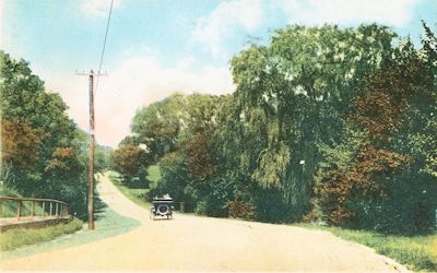
Main Road to Brookhaven, Bellport, L.I.
4-Post Card
about 1920
Br01.1.2-S
South Country Road
South Country Rd., Brookhaven, NY
Deitz
SouthCountryRoad/SouthCountryRoad_RoadToBrookhaven19200001
This post card shows South Country Road looking eastward probably from near the Bellport Village line.
10-24-2015 12:00:00
679
Looking westerly from Beaver Dam Creek
4-Post Card
Undate
Br01.1.2-S
South Country Road
South Country Rd., Brookhaven, NY
Deitz
historical\SCountryBrkhvn
South Country Rd., Brookhaven, L.I., NY. Looking westerly from Beaver Dam Creek and Valentine's Corner. House to left is likely that of William Sidney Hawkins (no longer extant).
10-25-2015 12:00:00
677
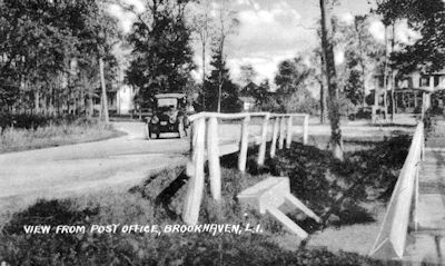
View From Post Office
4-Post Card
Post Mark 1922
Br01.1.2-S
South Country Road
South Country Rd., Brookhaven, NY
Deitz & Post Morrow Heritage Collection
030527/PM_044
View From Post Office, South Country Road at Valentine's Corner. House to right in Valentine House. "Post Office" is at Brook Store. Stream in Foreground is Beaver Dam Creek.
10-25-2015 12:00:00
680
Looking easterly at Beaver Dm Creek
4-Post Card
Post marked 1916
Br01.1.2-S
South Country Road
South Country Rd., Brookhaven, NY
Deitz
historical\SouthCountryRoad0001
South Country Road, Brookhaven, L.I., NY. Looking easterly, with Beaver Dam Creek in foreground and the Valentine's Corner curve (Fire Place Neck road to right).
10-25-2015 12:00:00
681
Looking east at Beaver Dam Creek
4-Post Card
1905
Br01.1.2-S
South Country Road
South Country Rd., Brookhaven, NY
Deitz
BeaverDamCreek\SouthCountryRdBeaverDamCreek1905
"Valentine's Corner" (Beaver Dam Creek and South Country Road, looking east), Brookhaven, NY
10-25-2015 12:00:00
678
Nathaniel Miller Jr & Oxen
2-Historic
About 1890
Br01.1.2-S
South Country Road
South Country Rd., Brookhaven, NY
Deitz
Miller\MillerFarmScenes\NathanielMillerOxSouthCountryRd4.3__1890
Nathaniel Miller Jr & Oxen, South Country Road at going over of Beaver Dam Creek, looking west. Photographer was standing on plot now known as Memorial Park.
10-25-2015 12:00:00
682
At LIRR Viaduct
2-Historic
1900
Br01.1.2-S
South Country Road
South Country Rd., Brookhaven, NY
Deitz
historical\south_country_rd_viaduct
South Country Rd. railroad viaduct, looking north. The train station was about 1/4 mile east (right) of this overpass.
10-25-2015 12:00:00
684
Montauk Hwy at South Country Rd., Brookhaven, NY
2-Historic
1958
Br01.1.2-S
South Country Road
South Country Rd., Brookhaven, NY
Van Lith
Montauk Highway\Montauk Hiway 1958
Montauk Highway, looking east, at the intersection with South Country road (to lower right).
"It was taken from Waldron's garage (Br04.5-S) where South Country Road intersects with Montauk Highway. The 25 cents gas station later became an Arnold day old bread place. Beaver Dam Creek headwaters runs behind it and for this reason, to protect it, Post Morrow bought the whole ten acre strip. The billboard signs on the right belonged to Malcolm Stewart and his GE appliance store which was just to the right on South Country road. The truck further down on the right side of the road is where Jim's deli and the Fire House now are. When this picture was taken, circa mid-50s, Charles Engelhardt had a house there (Sears ), which you can see through the trees." (Van Lith). Further in the distance is the site of the Sue's Haven tavern (Br04.3-S0, now site of the fire department maintenance garage).
10-26-2015 12:00:00
683
South Country Rd, South Haven, NY
4-Post Card
1905
Br01.1.2-S
South Country Road
South Country Rd., Brookhaven, NY
Deitz
..\photos\030527\PM_024
South Country Road, South Haven, NY. Charles Carman House is noted to be to the left. If so, this places the location as being on the section of the highway now known as Old South Country Rd.
10-25-2015 12:00:00
685
Montauk Highway at South Haven, NY
2-Historic
Before 1936
Br01.1.2-S
South Country Road
South Country Rd., Brookhaven, NY
Ken Hard
Hard\AerialLookingSW_e2
Montauk Highway, South Haven, NY, at the intersection with Gerard Road.
The house in the center is the old Carman's residence and inn (SH02), no longer extant; it was torn down about 1936.
This intersection was eliminated when the Sunrise Highway expressway was constructed in 1958; access to Gerard Road now is only avilable from the north side of Sunrise Highway.
The access road (by then overgrown) to the Carman's Mills dam and mill pond can be seen at the bottom of the picture. While a portion of the mill pond remains, the area at the bottom of the picture is now occupied by Sunrise Highway.
The barn and residence in the upper left was the Hard estate dairy farm; they are still extant.
10-26-2015 12:00:00
686
Goin' Over of Carman's River, South Haven, NY
2-Historic
Early 20th century
Br01.1.2-S
South Country Road
South Country Rd., Brookhaven, NY
Bellport-Brookhaven Historical Society
historical\H0001
While the back of the photograph at the Bellport-Brookhaven Historical Society has the caption quoted below, this is likely the bridge over the Carman's River in South Haven, not the crossing of Beaver Dam Creek at Beaver Dam Road.
There are several post cards in the Post Morrow Foundation Historical Collection which use this photograph and identify the Carman's River as the location. The width of the waterway is more consistent with that of the Carman's River at South Haven.
The caption on the photo image at the Historical Society reads: "Bridge over Beaverdam Creek. Probably taken by Walter E. Tamlyn, long time summer resident of Brookhaven. Believed to be bridge on Beaverdam Rd. taken late 'teens' or early 1920's Elizabeth Tamlyn Harris"
10-26-2015 12:00:00
687
Goin' Over, Carman's River, South Haven
2-Historic
Uncertain
Br01.1.2-S
South Country Road
South Country Rd., Brookhaven, NY
Post Morrow Foundation
030613\PMb030613 042
Photograph is identified on back. The highway is South Country Rd. The figures on bridge are reported to be Mrs. Whitbeck and her son. This picture is likely at or near high tide (compared previous image.)
10-26-2015 12:00:00


