Loading...

Historic and Natural Districts Inventory Form

Return to Sites Table of Contents

Unless indicated below, this is a transcript of the original Society for the Preservation of Long Island Antiquities/Town of Brookhaven survey form. Corrections to obvious typographical and spelling errors have been made. Corrections to factual errors, updates or comments on the information are either enclosed in [square brackets], or will be clearly indicated as updated material. Since most of the surveys were conducted in the late 1970’s and early 1980’s, much of the information reflects that time period.

Sites with an Inventory Code suffix of “S” are supplemental sites not included in the original surveys.

Historic and Natural Districts Inventory Form

Br01

07-26-1982

11-25-2011

Click for

Photos and images
Photo
People
Other Links
Printer Friendly

Submitter

Submitter Name:
Town of Brookhaven/SPLIA
Submitter Address:
Town Hall
205 S. Ocean Ave.
Patchogue, NY 11772
631-634-7806
Brookhaven Community Development Agency

Identification

Brookhaven Hamlet District
Suffolk
Brookhaven
Hamlet of Brookhaven

3-Description

The hamlet of Brookhaven is the community next easterly of the Village of Bellport, on the Great South Bay, at South in the Town of Brookhaven, Suffolk County, New York on Long Island.  It is not an incorporated village under the laws of the State of New York, although it is sometimes known as Brookhaven village.  Until 1873, it was known as "Fireplace." 

As a hamlet (and unlike an incorporated village), its boundaries are not fixed by law, but by tradition.  At the South is the Great South Bay—that large bay between mainland Long Island and Fire Island.  Traditionally, the northern boundary was the Montauk Highway and the properties along it, but today the Sunrise Highway,  the major east-west road along southern Long Island, is perhaps a more convenient boundary.  The traditional eastern boundary is Little Neck Run (a small north-south creek to the east of Old Stump road) and then the Carman's river to the south.  This boundary was (more-or-less) the division between the old Brookhaven and South Haven school districts.  The western boundary is a bit more amorphous.  The traditional western boundary was said to be Clam Hollow—a marshy hollow east of the George Washington Lodge and west of the old Hubert family estate.  Later, Otter Hollow (now the location of aptly named Bellhaven avenue) became the traditional division. Today, some consider that Brookhaven hamlet extends westerly all the way to Mott Creek and Bellport village line.  This section of Dayton's Neck, between Bellhaven avenue and the Village of Bellport, was sometimes known as West Fireplace or West Brookhaven. 

Brookhaven hamlet is situated on three of the old historic "necks" along the Great South Bay— Fireplace neck at the east, Tarmen's Neck at the center, and all (or perhaps just the eastern portion) of Dayton's Neck at the west.

South Haven and Brookhaven hamlets have long been closely associated communities.  For a time, both were called "the Fire Place."  And today they share the same postal district—11719, Brookhaven.  Suffolk County land use maps now consider both Brookhaven and South Haven as being within the same "hamlet," although this is not the view of the residents.  If one accepts the view that Brookhaven hamlet extends all the way to the Village of Bellport, then the western portion of the hamlet is in the Bellport postal district—11713.  This western portion is also considered to be within Brookhaven hamlet by the authors of the Suffolk County land use maps.

Brookhaven hamlet (as well as South Haven) is now entirely within the South Country School District.  The Brookhaven Fire District extends from Bellhaven avenue on the west into Mastic neck and Shirley on the east (on the eastern side of the Carmen's river, essentially between the river and William Floyd parkway.)

The "Fire Place Historic District" is a defined subsection of Brookhaven hamlet.  The boundaries of the "Brookhaven Village Association" are also defined in their bylaws.

[This section extensively rewritten and updated from original survey form.]

4-Significance

In 1664, the proprietors of the Town of Brookhaven purchased a large tract of land, known as "the Old Purchase at South," from the native peoples.  Soon after this purchase, the land immediately along the Great South Bay was subdivided into fifteen acre meadow lots.   While the meadow lots were an important agricultural resource, because of the marshy nature of the meadow lots, they were not suitable for permanent settlement. 

The first road to the area from the more settled communities of the Town of Brookhaven on the north shore was Old Town road.  This road provided north to south access to the meadow lots for the proprietors of the Town.  Remnants of this road remain as Old Town road, Fire Place Neck road, and Bay road.  South Country road was soon developed as the main east-west highway along the south shore branching east and west as it came to Fireplace neck.

In 1676, additional fifteen acre shares were laid out of upland as near or adjoining each man's meadow share as could be done.  The major dimension of these lots (now totaling 30 acres) were north-south.  They were known as "the long lots."  North of these shares additional lots were laid out, the major dimension being east-west.  These were know as "the short lots," that is, the short side was north-south.  (For a more detailed description of these lots see p. 4, Shaw's "History.")  Because the new lots now included upland, they were suitable for permanent settlement.  This pattern of lots can still be seen in modern property lines and aerial views.

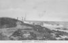
The first permanent European settlers on Fireplace neck were probably members of the Thomas Rose family, perhaps in the late seventeenth century, but certainly by the early eighteenth century. Fireplace was important as a farming area, and, because it gave easy access to the Bay and to the Ocean through the Inlet directly opposite Carman's River (now known as "Old Inlet," which has since filled in), was also home to fishermen and baymen. 

Beaver Dam Road, which crosses the Neck east to west, was laid out in 1735 to give farmers access to the River and to their various lots; this road was laid out essentially along the north end of the long lots.   By 1836, there were thirteen residences on Beaver Dam Road, many farmhouses owned by the Rose family descendants.

Late in the 19th century, as the farming and fishing dwindled, and travel between New York City improved because of rail road transport,  the area became a favored summer retreat for artists and writers.

Many of the early houses remain, several unchanged in appearance. The area also retains many of its local family cemeteries.

The old Southaven Church was moved to Brookhaven Hamlet in 1958 (See Br09A, "Old South Haven Presbyterian Church"). The church now stands on a rise at the corner of Beaver Dam road and South Country road, on land purchased from the Post Family. (See Br09B, "Post Homestead"). This family also donated to the Village Association land at the bottom of Beaver Dam Road known as Squassux Landing (see Br16). Boats have been tied up there for over two hundred years.

For a more comprehensive history of the Hamlet, see Shaw's "History" elsewhere on this site.

[This section has been extensively rewritten and updated from the original survey form.]

5- Map

NYS DOT Bellport Quad

6-Sources

"Map of the County of Suffolk" by David Burr, published by the Surveyor General, New York: Rawdon, Wright & Co., 1797. Repository: Wm. Floyd house, Mastic, New York. "U.S. Coast Survey Map, 1838. Repository: Library of Congress, Washington, D.C. Bigelow, Stephanie, "Bellport and Brookhaven," Bellport-Brookhaven Historical Society, 1968.

7-Threats to Area

By Zoning
By Roads
By Developers
By Deterioration
Other: At least 100 acres of farmland not being farmed, permanently.

8-Local Attitudes Toward the Area

Very positive.

Photo

Photos and images

Prepared By

Ellen Williams, research assistant.

Supplemental Material

August 1907: Through the generosity of Mr. [Malcolm] Fraser and Mr. [James] Post, Fire Place Creek is being cleared out from Beaver Dam [Road] to the bay.

Patchogue Advance, 1 Oct 1929, p.4:
The land owners on each side of Beaver Dam creek held a meeting Saturday evening for the purpose of dredging the creek from the Beaver Dam bridge to the bay. Those present at the meeting were August L. Starke, Sr., James H. Post, Raymond Storb, Thomas Morrow, Jr., Preston Smith, and Mr. Cross. This will be a great improvement for Brookhaven as it will be a fine harbor for motorboats to run into for winter as neither Brookhaven nor Bellport have a harbor. Several other land owners, who live in the city, are interested in the dredging but were unable to attend the meeting.
It is interesting to note the simpler age. Today, such ad hoc dredging likely could not be done today without many governmental reviews and permits, and perhaps not allowed at all. While the Town of Brookhaven likely "owned" the creek bottom (at least the tidal portion), they appear not to have been at all involved in the project.

Patchogue Advance, 12 November 1929, p. 2.
For several weeks the property owners along Bay Avenue and Beaver Dam Road in Brookhaven have met Saturday evenings to discuss and plan on having the creek known as Beaver Dam creek dredged out from the bay to Beaver Dam Road, a distance of one and one-half miles, and they plan to build a breakwater in the bay. Frank Corwin has been appointed overseer. Plans are not yet complete, though bids have been received from various dredging companies. This will make a fine stream and enhance the beauty of Brookhaven. The property owners along the stream are Messrs. Raymound Staub, Thomas Morrow, Jr., James H. Post, Clinton Smith, Preston Smith, George Miller, John Reddall, Messrs. Frudenthall Cross and August L. Starke. The improvements will also provide winter quarters for many boats.

[Abt 1953: Plane Crashes into Great South Bay off Fireplace Creek.
From the Archives of the Long Island Advance, 30 August 2007.
 "A big plane took a nosedive into the bay off Fireplace Creek [Beaver Dam Creek]; the two aviators escaped serious injury. Next day their comrades from Montauk came up and salvaged the machine."