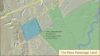
During the Colonial Period, in addition to public levies (taxes), Town churches of Eastern Long Island (Suffolk County, NY) were frequently supported by the setting aside of land parcels (Manse or Parsonage Lands). Income from these lands (such as rents) were used exclusively for the support of the Town church and its ministers. Frequently they were farmed by the church's ministers for their sustenance. In Fire Place (Brookhaven and South Haven hamlets), one such parsonage parcel stretched from Old Town and South Country Roads eastward to Little Neck Run, and northward from approximately the modern LIRR tracks to the colonial South Country road (modern Montauk Highway. See map.)
At its founding, the Town of Brookhaven was under the jurisdiction of Connecticut. It established a Town church in the manner of New England and its minister was subject to the ecclesiastical authority of Connecticut church bodies. In 1664 all of Long Island came under the jurisdiction of the Duke of York. There was but one Church in the colony, the Established Church, the Church of England. Members and supporters of the Church of England were known as the "church party." However the Town maintained its practice of supporting a Town Church which "dissented" from the established Church of England. Members and supporters of the Town Church were called the "dissenting party." Legally, the Town Church was not a church at all -- there being but one Church, the Church of England. On 30 April 1697, the Towns of Smithtown and Brookhaven, and residents of the Manor of St. George, called the Rev. George Phillips to be their minister. He was born in 1664 and graduated from Harvard in 1686. He was the second settled pastor at Setauket, but was not ordained until 1702. It is important to note that Rev. Phillips had a contract with Town for his services. In 1719, Richard Floyd and William Smith objected to the New York Royal Council about having to pay to repair the Town House (the church meeting house) and by having to support the salary of the Town minister. The Royal Council punted, and did not rule specifically on the the practice, indicating that it was a matter for the courts. That the Town had a contract with its minister was a factor in their decision — business law vs. religious law—this being a matter of law to be decided by the courts. Until 1739, the Town had only one minister for the whole Town, the Rev. George Phillips. Apparently Floyd and Smith did not pursue the matter in the courts.
In 1741, Brookhaven Town authorized splitting the Parsonage Lands between the church party (e.g., Anglicans, the Caroline Church) and dissenting party (e.g., Presbyterians, the Setauket Church and subsidiary congregations). This division likely was precipitated because of Rev. Phillips' death in 1739—i.e., the Town no longer had a contract to legally justify their continued direct support. Referees or arbitrators were appointed by the Town trustees to specifically parcel out Parsonage Lands between the two church parties. On 5 October 1741 the Referees reported. [Reference: Town of Brookhaven Records]. Apparently, at that time, those lands apportioned to the church party were transferred to the Vestry of the Caroline Church and were no longer subject to Town control in an ecclesiastical context. Those lands apportioned to the dissenting party remained under Town control and its Trustees until 1756/59. It is interesting to note that at that time the Town trustees were considered to be of the dissenting party.
Fifteen years later, in 1756, the Town authorized the transfer of those Parsonage Lands (previously parceled out by the referees to the dissenting party by the 1741 action) to a separate body of trustees (acting on behalf of the dissenting party) to be sold and "... the moneys arising from said sales to be put out and kept at interest, thereby to enable them to the better support such Presbyterian or dissenting minister of the gospel ...." [Reference: Brookhaven Town Records] In 1759, these lands were formally conveyed to these trustees. [Reference: Brookhaven Town Records] After these actions, the Town of Brookhaven apparently no longer was directly involved in the support of the dissenting party.
So far, we have not found to whom the Fire Place Parsonage Lands were first sold, nor how the proceeds of the Parsonage Land sales were actually distributed. [5] Land records indicate that Joseph Terry owned the Fire Place Parsonage Lands at his death about 1804; we have not found when or from whom he acquired it. Robert Ellison purchased it in 1805 and advertised the property for sale in 1807.[1] Apparently the parsonage farm was not sold in 1807, for Elizabeth Ellison, his wife, was still offering the farm for sale in 1836 [2]. On 10 Nov. 1865 John W. Petty conveyed the property to Joshua Carman [3]. By the early 20th century (12 Sep 1912) the property was owned by the Clyde Development Corp. [4] Subsequently it was subdivided to many owners including the Post Office, the Brookhaven Fire District, commercial properties and private dwellings.
[1] Suffolk Gazette (Sag Harbor, NY), 9 March 1807, p. 4. Advertisement. FOR SALE. A valuable FARM, situated in the township of Brookhaven, in Suffolk County, on the south side of Long Island, about two miles to the westward of the Fire-place Mills. It was formerly the parsonage of South-Haven, and contains about eighty acres of land, on which is a good two-story dwelling-house, with tolerable barn and other out-houses. The land is mostly of it a loomy soil, and lies opposite the South Bay, which abounds with shells, sea-weed and fish manure. Also a piece of Salt meadow, lying within one mile of the house, which will cut about seven loads of hay. Also two lots of Timber-land, in the great and east division, containing one hundred acres each, which will be sold with the place or separate, as may best suit the purchaser. For further particulars enquire of ROBERT ELLISON, On the premises.
[2] The Corrector (Sag Harbor, NY), 27 February 1836, page 4. Advertisement FOR SALE. The FARM commonly called the parsonage, containing about 80 acres of land; one half of which is well timbered; — on the same is a large commodious DWELLING-HOUSE, A good Barn, &c. &c. ELIZABETH ELLISON
[3] Deed records Libor 134 page 445.
[4] The County Review (Riverhead), 20 August 1915, page 17
[5] While we have not found to whom the Parsonage Lands were first sold, nor how the proceeds were distributed, it is likely that those lands closely associated with individual Presbyterian parishes were conveyed to those parishes. We also know that William Smith, of the Manor of St. George, purchased materials for a dwelling house for the ministers of the South Haven Presbyterian parish in 1851 (from his account books). This dwelling was likely erected on the Fire Place Parsonage Lands. So it is not unreasonable to expect that the Fire Place Parsonage Lands eventually became the property of the South Haven parish.
An article that appeared in the Patchogue Advance, 23 Mar 1961, p. 9, indicated that the Rev. David Rose was the last minister of the South Haven Presbyterian Church to have been a resident of the Fire Place Parsonage Lands. Independent confirmation of this fact has not been found. Rev. Rose died in 1799 and, as it is said, "he must have lived somewhere, somewhere fairly near the church I expect." Unfortunately, records of the South Haven Presbyterian Church before 1800 are no longer extant. There is no indication in the extant records of the sale of any manse property. In 1800, the trustees paid to rent a dwelling for Rev. Rose's successor, Rev. Robert H. Chapman, who stayed only a short while. Immediate successor ministers resided in Middle Island. In 1802, the trustees paid John Rose, Esq. rent for a dwelling for Sarah Strong Rose, Rev. David Rose's widow. All of which is suggestive that Rev. David Rose indeed was the last minister to reside on the Parsonage Lands, and that these lands were sold by the South Haven parish shortly after his death, likely to Joseph Terry.
* A manse is a clergy house inhabited by (or formerly inhabited by) a minister usually used in the context of Presbyterian or United Church (Congregational) traditions, most frequently those of Scottish origin. Derived from the Latin mansus, "dwelling", from manere, "to remain". By the 16th century the term meant both the dwelling and the amount of land needed to support a minister and his family. Since the Town of Brookhaven was of English origin, the term parsonage lands was used in Town records. In modern times, manse is frequently used among churches of Presbyterian tradition regardless of their origin.