Click on image for enlarged view.
344
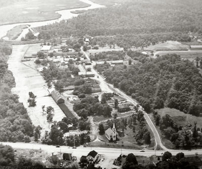
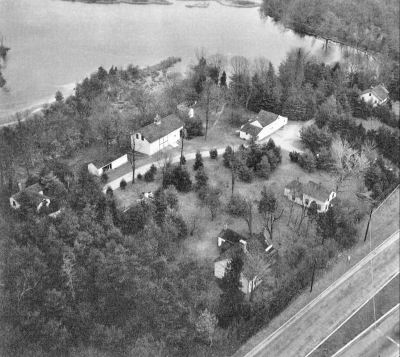
Aerial View of South Haven
2-Historic
1946
SH01
South Haven Hamlet District
Ken Spooner
http://www.spoonercentral.com/GoingOver/GoingOver.html
10-21-2005 12:00:00
355
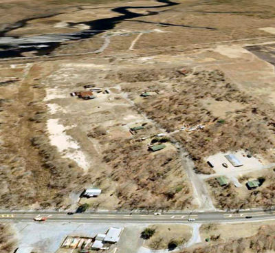
Satellite View
1-Modern
abt 2005
SH01
South Haven Hamlet District
Google
http://earth.google.com/
This image uses Google Earth to get a satellite "perspective" view close to the 1946 aerial image above.
Many of the farm buildings are gone. The South Haven Church has been moved to Brookhaven Hamlet (a faint outline of the original footprint is still visible). While the tree line east of the duck runs has pushed west, the line of the original duck runs boundary is still visible. Overall, the site appears less wooded than in 1946.
Note that the satellite views were originally "plan" (i.e., essentially straight down) images; Google Earth uses interpolation techniques to simulate the perspective view, which leads to some distortion (but is remarkable, none the less).
10-22-2005 12:00:00
347
South Haven Presbyterian Church
2-Historic
Early 20th century.
SH01
South Haven Hamlet District
Ken Spooner
http://www.spoonercentral.com/GoingOver/G2.html
This picture shows the South Haven Presbyterian Church and an adjacent dwelling in South Haven probably early 20th century. The dwelling is the Robinson-Miller House (Ref. ID SH05)
See Br09A for more pictures of the church building.
See Br09A for more pictures of the church building.
10-18-2005 12:00:00
356
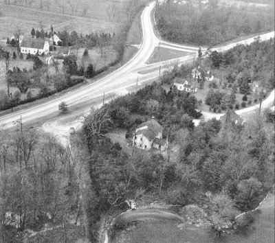
Aerial Looking South West
2-Historic
Bef 1936
SH01
South Haven Hamlet District
Original from Kenneth Hard
Montauk Highway (South Country Road) goes west--southwest at the top center of the picture. To the right is the original terminus of Horseblock Road before the construction of Sunrise Highway. The house in the upper right has been identified as the old Carman family homestead, inn and store. The larger 2-story section (east section) was torn down about 1936. The smaller 1 1/2-story section (west section) was eventually moved to Brookhaven Hamlet about 1950 and is now the Stirling-Clevidence House (Br37.01-S)
The Robinson farm is on the left side of Montauk Highway. Just out of the picture in the foreground would have been the location of the Carman's Mills. Most of the mill structures remained until the construction of the Sunrise Highway extension about 1958. What appears to be a cleared right-of-way from Montauk Highway south likely lead to the Mill dam and Mill.
The Robinson farm is on the left side of Montauk Highway. Just out of the picture in the foreground would have been the location of the Carman's Mills. Most of the mill structures remained until the construction of the Sunrise Highway extension about 1958. What appears to be a cleared right-of-way from Montauk Highway south likely lead to the Mill dam and Mill.
357
Aerial view looking northeast
2-Historic
bef 1936
SH01
South Haven Hamlet District
Original from Kenneth Hard
At the upper right is the Carman's mill dam. The house in the foreground is likely the old Carman's homestead, inn and store.
225
South Country Rd.
4-Post Card
1905
SH01
South Haven Hamlet District
Post-Morrow
RG3 Series 1
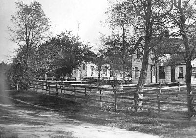
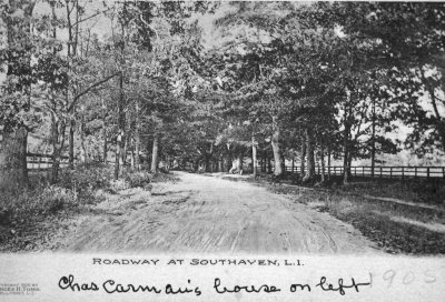
South Country Road in South Haven, probably looking east and approximately at the location of the South Haven School (now called the South Haven Academy).
The Charles Carman noted on the post card is likely the Charles (1830-aft 1900) who was one of Samual Carman, Jr.'s sons. An 1873 map shows a C. Carman on the north side of South Country Rd., a short distance east of its intersection with Horse Block Rd. Charles Carman is recorded in the 1900 census and therefore still living at that time. The post card is dated 1905. Charles has not been found in the 1910 Census.
The Charles Carman noted on the post card is likely the Charles (1830-aft 1900) who was one of Samual Carman, Jr.'s sons. An 1873 map shows a C. Carman on the north side of South Country Rd., a short distance east of its intersection with Horse Block Rd. Charles Carman is recorded in the 1900 census and therefore still living at that time. The post card is dated 1905. Charles has not been found in the 1910 Census.
386
South Country Rd. in South Haven, NY
2-Historic
Uncertain, probably early 20th century
SH01
South Haven Hamlet District
Post Morrow Historical Collection
vanLith/Southaven3enhanced
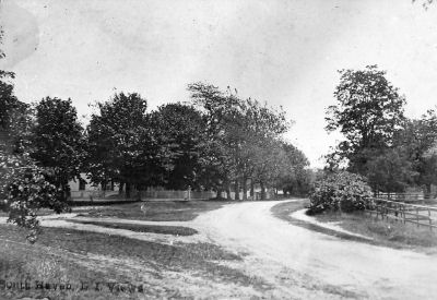
After carefully comparing this photograph with others, principally early photographs of the Carman homestead, inn and store in South Haven, I and others now believe that this photograph shows the South Country Rd. in South Haven looking east, probably early 20th century but after the advent of motorized vehicles.
The house to the left is likely the Carman homestead (SH02). The road to the left is likely Gerard Rd. leading north to Yaphank.
The house to the left is likely the Carman homestead (SH02). The road to the left is likely Gerard Rd. leading north to Yaphank.
431
South Haven
1-Modern
Uncertain
SH01
South Haven Hamlet District
Van Lith
../photos/vanlith/AerialSouthHaven
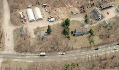
In this photograph, Montauk Highway is in the foreground and the Carman's River is to the left (east). The Gilbert Miller house is left of center (SH05). Slightly right of center is the Robinson House, moved to this location in 1958 from across Montauk Highway. This house is of relatively modern vintage, probably built in the 1940s-1950s. The barns are of the old Hard Estate, now owned by Ron Bush. The large barn now houses an excellent collection old farm implements and tools. The road at left leads to the former Robinson Duck Farm, now owned by Suffolk County.
09-20-2007 12:00:00


The historic South Haven Presbyterian Church (Ref. ID 09A) which faces Montauk Highway was nearly surrounded by the farm. I'm told that the smell of the farm was nearly unbearable during much of the year, and that was one of the reasons which lead to the church being relocated a few miles west to a new setting in Brookhaven Hamlet. Fortunately, the congregation had acquired an alternate meeting house in the old Methodist Church in Brookhaven (Ref. ID Br29C) in the early 1940's, when the Methodists and Presbyterians consolidate their congregations and structures.
In April 1991 the site, including the core barns and out buildings, were acquired by Suffolk County via the Trust for Public Land.