
 The historical maps section is being rebuilt. Some maps or descriptions may not be available.
The maps are being migrated to a historical maps “Album” within the “Hamlet People” database. This section, because of its integration with the “Hamlet People” database, is generally easier to maintain.
| Year | Map Name | Page Link | Map Comment | Cartographer | Publisher |
|---|---|---|---|---|---|
| 1829 | 1829 Burr Map | 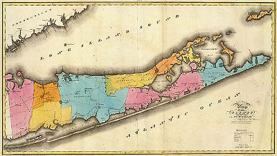 |
This 1829 map of Suffolk County is from the Atlas of New York State published under the direction of Simeon DeWitt, Surveyor General of New York by David H. Burr. | Simeon De Witt, Surveyor General of New York | David Burr, from his Atlas of the State of New York, 1829 |
| 1851 | 1851 Nautical Map | This map is the Fire Place portion of an 1851 nautical chart titled Nautical Chart of Western Part of the Southern Coast of Long Island. The full chart is available at the National Oceanic and Atmospheric Administration Historical Map and Chart Collection.Since the map was designed as a nautical chart, the accuracy of the land portions is suspect. There is evidence that the topographical portion of the map is based on surveys conducted in 1836. Click on image to see the map full scale — the quality of the available image is such that it can only be seen clearly at full scale | National Oceanic and Atmospheric Administration Historical Map and Chart Collection | ||
| 1858 | 1858 Chace Map of Hamlet | In 1858, the Hamlet was still called Fire Place or Fire Place Neck. It was not until 1871 that the name officially became Brookhaven Hamlet. The map is from a tracing of a section of a large wall map “Atlas of Suffolk Co.,” published by J. Chace Co., New York, 1858. | John Douglass. Philadelphia, PA | J. Chace Co., New York | |
| 1858 | 1858 Beaverdam Road | 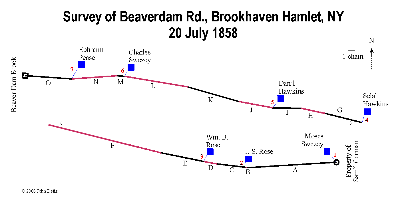 |
On page 99 of the Records of the Town of Brookhaven, 1856-1885 is recorded a “survey of a three rod public road from the land of Sam’l Carman at Squawsucks, across Fireplace Neck to Beaver Dam lower crossing — Magnetic course.” This road was Beaverdam Rd., and its right-of-way was 49.5 feet (3 rods). This survey is useful as it indicates some of the residences on the road at that time, and their exact locations. The table below records the actual surveyor’s dimensions and the map below is drawn from these dimensions. N. Miller, Jr. was the Surveyor. The survey was apparently conducted 20 July 1858. It is interesting to note that this survey does not agree completely with the 1858 Chace map. The house labeled J. Carman on the Chace map was likely the Moses Swezey house indicated below; and according to the survey, Ephraim Pease had a house between Charles Swezey and Beaverdam Creek; no house is indicated on the Chace map. The road’s point of beginning is “south thirty seven and a half degrees east one chain & twelve links” from the southeast corner of Moses Swezeys house. A surveyor’s “chain” is 66 feet (or 4 rods); each chain contains 100 links (7.92 inches). Each “survey section” is labeled on the map | N. Miller, Jr. was the Surveyor | Town of Brookhaven |
| 1858 | 1858 Road Survey of South Country Rd. | 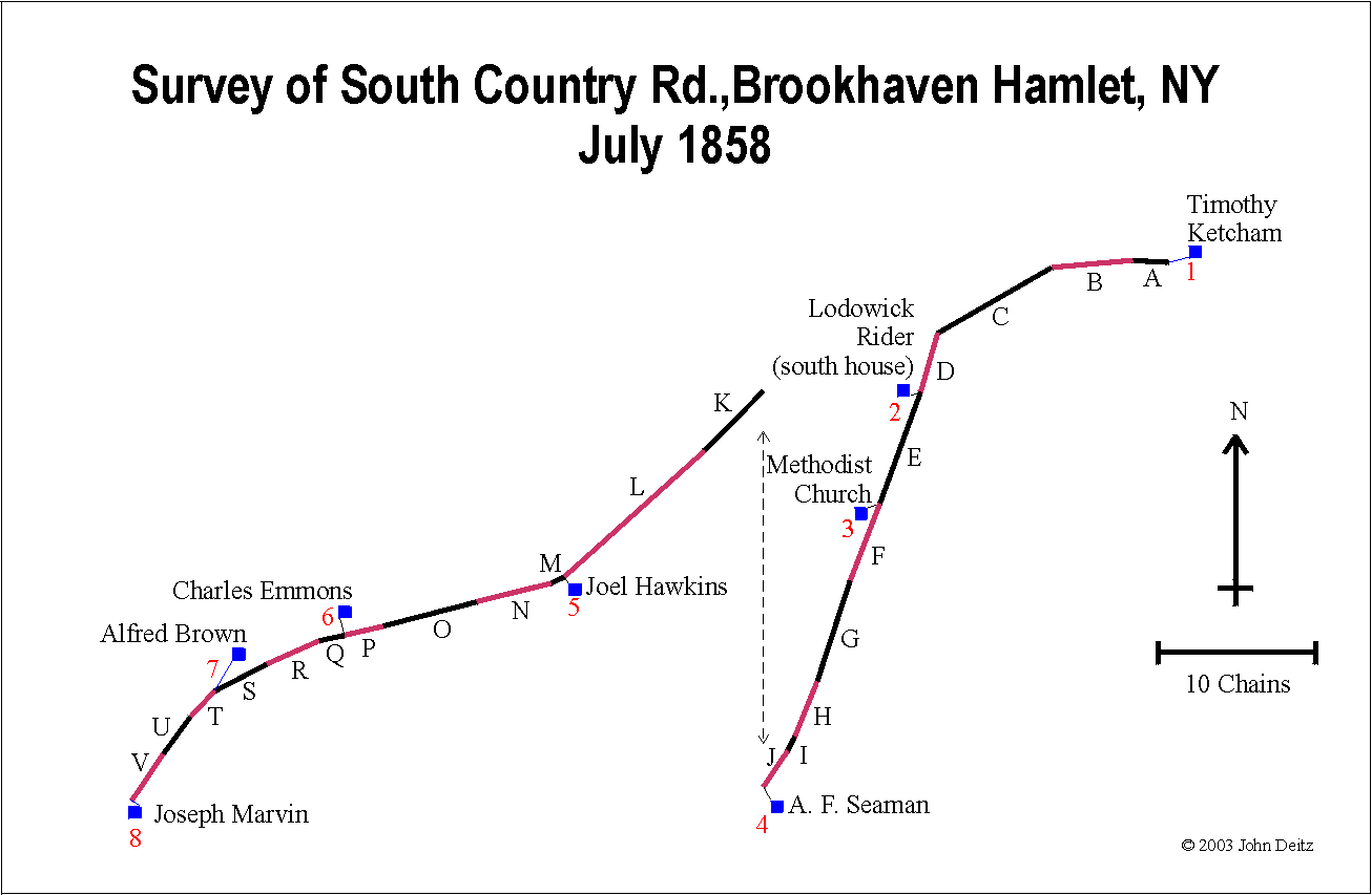 |
On page 100 of the Records of the Town of Brookhaven, 1856-1885 is recorded a “survey of a four rod public road from the road out of Fireplace Neck across the upper crossing of Beaver Dam Brook west to Marvins house in the Hollow — Magnetic Course.” This road was the road now known as South Country Rd., and its right-of-way was 66 feet (4 rods). This survey is useful as it indicates some of the residences on the road at that time, and their exact locations. The table below records the actual surveyor’s dimensions, and the map below is drawn from these dimensions. N. Miller, Jr. was the Surveyor. While there is not a date recorded for the survey, it is likely conducted in July 1858, as its record immediately follows the one dated 20 July 1858 for Beaverdam Road. There are some differences between the houses indicated on the survey and the houses indicated on the 1858 Chace map. “Lodowick Riders” house is not indicated on the Chace map (although it may have been either the “Bartow” or “Smith” houses identified by Chace — the “Smith” house being most likely.). The house identified as Charles Emmons on the survey was identified as C. Emmonds on the Chace map. And the “Joseph Marvins” house used as the anchor for the end-point on the survey is not identified on the Chace map, but is likely one of the unidentified structures near the house labeled “J. Rider.” It is interesting to note that Joseph Marvin does not appear on the 1850 or 1860 censuses, suggesting that he had but a brief sojourn in Fire Place. The survey started “for the centre of the road from the S.W. corner of Timothy Ketchams main house, south 75° W. one chain & 34 links….” A surveyor’s “chain” is 66 feet (or 4 rods); each chain contains 100 links (7.92 inches). Each “survey section” is labeled on the map | N. Miller, Jr. was the Surveyor | Town of Brookhaven |
| 1859 | South Haven before 1859 | 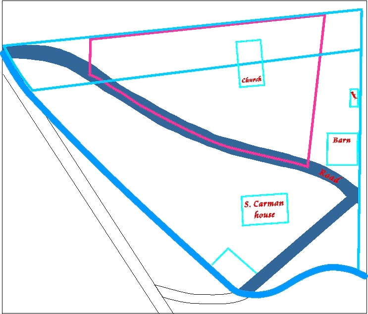 |
The original of this map is identified with the following label: “This is an old map of the South Haven Church’s land and the adjacent Property of Samuel Carman. Mr. Carman gave the site of the present edifice in exchange for the original site. As he died in or about the year 1869, this map was made before then. It was pasted on a copy of THE NEW YORK EXPRESS dated January 15, 1859, and so was probably drawn prior to that date.” | Attributed to Samuel Carmen, Jr. | Original is hand drawn |
| 1873 | 1873 Brookhaven Hamlet | 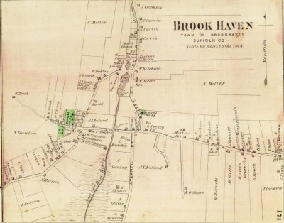 |
On this map, South Country Rd. is called Main St., the east end of Beaverdam Rd. is called South St.; the west end of Beaverdam Rd. (which is a dead end) is called Ruland Ave.; Fire Place Rd. is called Beaver St.; and Bay Ave. is called Atlantic St | F. W. Beers | Beers, Comstock & Cline, New York |
| 1873 | 1873 Southern Town of Brookhaven | This is an 1873 map of the southern portion of the Town of Brookhaven. The solid curving line running west-east at the bottom of the map is the proposed path of the South Side Railroad extension from Patchogue to Eastport, later to become the Long Island Rail Road. The actual tracks were not laid along this path when constructed in 1879-1881, but in a slightly more northerly, nearly straight-line path without the curve south into the center of Bellport Village. Montauk Hwy. was then built adjacent to the railroad, bypassing the Village. | F.W. Beers | Beers, Comstock & Cline, New York (Reprinted Compass Ventures, Inc., 1971) | |
| 1884 | 1884 Andrews Property Survey | This is a survey map of the Andrews property in 1884, between the Long Island Rail Road (then the South Side Railroad) and South Country Road (then also known as Main Street.) It is particularly helpful in showing a fairly exact location of structures along this section of South Country Road. On the back is handwritten: “Some of our land below R.R. Sarah Andrews 1884” The survey is in the collection available from the Post-Morrow Foundation. | Unknown | Unknown | |
| 1888 | 1888 Brookhaven Hamlet | This 1888 map is a detail from the Wendelken Atlas of Babylon, Islip, and South Part of Brookhaven (Towns) in Suffolk Co., N. Y. | Unknown | Wendelken & Co., New York | |
| 1900 | 1900 Survey Map of Tangier Smith Property | 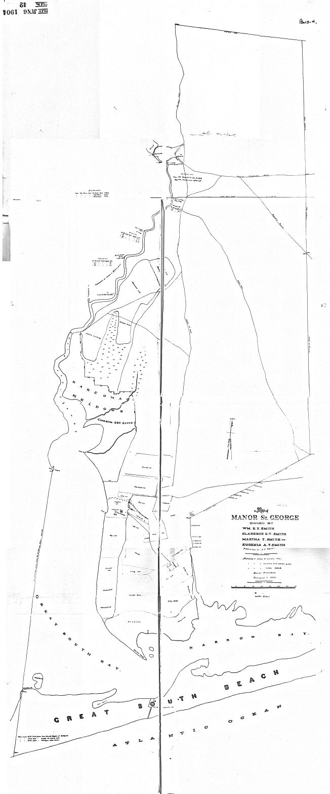 |
1900 Survey map of the Tangier Smith Property, on Mastic Neck, Suffolk County, NY, including the Carman’s River & Great South Beach (Fire Island) | Unknown | Unknown |
| 1902 | 1902 Map of Brookhaven and South Haven Hamlets | This map, circa 1902, is of Brookhaven Hamlet early 20th century, with property owners identified | Unknown | Unknown | |
| 1903 | 1903 USGS Moriches Quadrant NW | 1903 USGS Topography Map – Moriches New York Quadrant – NW quarter. These maps show the topography in considerable detail and accuracy. | Under direction of Edward A. Bond, NY State Engineer and Surveyor | U. S. Geological Survey | |
| 1903 | 1903 USGS Moriches Quadrant NE | 1903 USGS Topography Map – Moriches New York Quadrant – NE quarter. These maps show the topography in considerable detail and accuracy. | Under direction of Edward A. Bond, NY State Engineer and Surveyor | U.S. Geological Survey | |
| 1903 | 1903 USGS Moriches Quadrant SW | 1903 USGS Topography Map – Moriches New York Quadrant – SW quarter. These maps show the topography in considerable detail and accuracy. | Under direction of Edward A. Bond, NY State Engineer and Surveyor | U.S. Geological Survey | |
| 1903 | 1903 USGS Moriches Quadrant SE | 1903 USGS Topography Map – Moriches New York Quadrant – SE quarter. These maps show the topography in considerable detail and accuracy. | Under direction of Edward A. Bond, NY State Engineer and Surveyor | U.S. Geological Survey | |
| 1915 | 1915 Part of the Town of Brookhaven, Plate No. 9. | The most southerly portion which includes East Patchogue, Bellport, South Haven, and Mastic. | E. Belcher Hyde, Brooklyn | ||
| 1915 | 1915 Map of Part of the Town of Brookhaven, Plate 10. | The section north of plate 9, to the Main Line of the Long Island Rail Road. | E. Belcher Hyde, Brookhaven | ||
| 1915 | 1915 Brookhaven Hamlet, NY | This map is probable another version published by Belcher-Hyde. It was said to be 1915, but would have been slightly later than the 1915 Belcher-Hyde map, as this map shows Locust Road, which was constructed during the period 1915-1920+. | Uncertain. Merritt B. Hyde was the likely cartographer. | Uncertain. Probably E. Belcher Hyde, Brooklyn. | |
| 1926 | History of Locust Rd. (1926) | Susan David wrote a history of Locust road, Brookhaven hamlet, NY, while a 4th grade student at the Hampton Avenue school. She prepared maps of the street as it was arranged in 1926, 1946, and 1976. Her history and maps were based on interviews with residents then living on the street. | Susan David, age 10, 4th Grade, | Hampton Ave. School. 1976 | |
| 1946 | History of Locust Rd. (1946) | Susan David wrote a history of Locust road, Brookhaven hamlet, NY, while a 4th grade student at the Hampton Avenue school. She prepared maps of the street as it was arranged in 1926, 1946, and 1976. Her history and maps were based on interviews with residents then living on the street. | Susan David, age 10, 4th Grade, | Hampton Ave. School. 1976 | |
| 1947 | 1947 Survey Map of South Haven, NY |  |
This map shows land ownership in 1947 in the hamlet of South Haven, Long Island, NY | Unknown | Unknown |
| 1976 | History of Locust Rd. (1976) | Susan David wrote a history of Locust road, Brookhaven hamlet, NY, while a 4th grade student at the Hampton Avenue school. She prepared maps of the street as it was arranged in 1926, 1946, and 1976. Her history and maps were based on interviews with residents then living on the street. | Susan David, age 10, 4th Grade, | Hampton Ave. School. 1976 | |
| 1986 | 1986 Nautical Map Great South Bay (east end) | 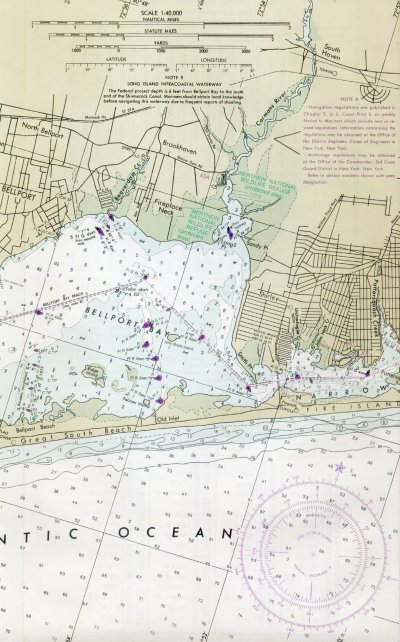 |
This nautical chart shows the east end of the GreatSouth Bay, some upland areas of Brookhaven Hamlet and environs, and the south ocean beach (South Beach or Fire Island). | Uncertain (U.S. Coast Guard?) |