
In this email, Dr. Richard A. Thomas documents his research that addresses, in part, the question of where the Chapel House (Lecture Room) was originally located, and whether it was moved more than once.
He found no evidence that the building was ever on the west side of South Country road, and that it was moved only once—from its original location close on to the roadway to a new more convenient siting somewhat further back.
From: Richard Thomas
Sent: Tuesday, September 15, 2009 1:17 AM
To: Ludlow, Eben
Cc: Deitz, John
Subject: Location of the “South corner” of the Lecture Room
Attachments: LectureRoom02.pdf
Hi Eben,
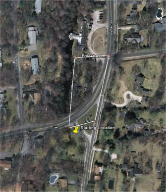
I used Google Earth to lay out the road more carefully using the 1876 Survey by Nathaniel Miller. For Google Earth, one uses bearings instead of “angles from the x-axis,” with bearings stated as values between 0° and 360° with true North, East, South. and West being 0°, 90°, 180°, and 270°, respectively.
Then I laid out each segment, beginning from the center of the South Side Rail Road bridge and working down to the center of the road at the NW corner of Timothy Ketcham’s field.
Since the direction, going backwards from the points as listed in the survey, is mostly south, the bearing is a value near 180°, with smaller numbers meaning to go a bit easterly when going southerly, and larger numbers meaning to go a bit westerly in going southerly.
Starting at the center of the railroad bridge, we get the following course when traversing the surveyed course in the opposite direction from which it is recorded:
163.7° 347.8 ft.
169.7° 122.8 ft.
172.7° 644.8 ft., which is 29 feet from the SE corner of the house formerly owned by John W. Bunce
177.7° 322.7 ft.
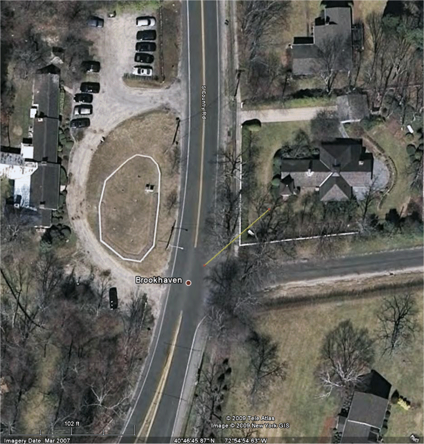
184.7° 77.9 ft., which is a point in the center of the road at the NW corner of Timothy Ketcham’s field, and 69.3 feet from the the South corner of the Lecture Room.
Total distance from the center of the RR bridge is 1,516 feet.
[The .7° in the angles results from correcting the magnetic courses to the true courses using the magnetic declination at Brookhaven hamlet in 1876 (about 8.3° — it was 7.97° in 1870 and 8.58° in 1880).]
We can be sure that the South corner lies 69.3 feet from the final point, but is it at a bearing of 48.7° (northeasterly), or a bearing of 228.7° (the opposite direction, southwesterly)?
[There will be some error in plotting the course from the S.S.R.R. bridge to the point, so the location of the South corner of the Lecture Room should also take into account the probable error in locating the point from which it is measured.]
The final point (the beginning point of the survey) seems to be near the center of the road at an extension of the north side of Chapel Ave. The center of the road in 1876 appears to have been a few feet to the east of where it is today.
Then I plotted where the Lecture Room would be if one interpreted
“the aforesaid point which bears North fifty seven degrees east from the South corner of the Lecture room one chain and five links”
as meaning that the direction is to be taken with the understanding that the point in the center of the road is the reference point for the bearing.
(Although, in standard English, one would think that the words ” which bears . . . from the South corner” would mean to take the “South corner” as the reference point. However, this point in the center of the road is the beginning point for this survey, so maybe the direction is given from the perspective of standing at the beginning point. It certainly makes more sense to give a distance to a South corner of a building if you are standing south of it.)
This puts the Lecture room’s South corner about where the Lecture Room is shown to be situated on the 1873 map. Google Earth isn’t designed to do accurate survey work, so my point could be off by a 50 to 100 feet.
It would also mean that when the congregation thanked Mr. Post “for his generosity in giving more land, and, moving the Chapel at Brookhaven,” [Trustee Minutes of the Parish of South Haven, Annual Parish Meeting, Saturday, June 25, 1904] after the “new road” (Chapel Ave.) was put it, that the move was only a small move, as would have been expected from the shape of the property that Mr. Post purchased and gave to the South Haven Parish.
If this was a second moving of the Chapel House, then the first, if there was one, would have probably had to have taken place before 1871.
It may be possible to determine whether it was moved between 1848 and 1871 by deciphering the description of the property conveyed by Richard Corwin Jr. and his wife, Dency, to the Fire Place Congregational Church (for $150) in the deed of 11 Apr 1848 (Liber 55, page 244).
When the land “on the South side of the Town” was divided by the Town of Brookhaven on December 10, 1733, “Bever Dam River” was to have “fower pole” wide margins reserved on both the west and east sides for “waterings” and for “sefesient Highwaye to and from them.”
But on 04 Jun 1740, they did decide to sell off an acre of land in that land reserved for waterings and highways: “Laid out to John Hulse, a piece of land at South, . . . in the fire place Neack, adjoining to Beaver Dam River, bounded East by the highway, containing about one acre.”
Then in 1750, the Trustees reserved 6 rods on the east side of Beaver Dam River and made the road a public road down to the cross road at the “lower going over,” by which is meant the “Beaver Dam Road cross road.” [Today’s South Country Road crossing being the “upper going over.”]
The lot sold to John Hulse appears to have been inherited by Thomas Hulse, then sold to Daniel Rose. The roads, on both the west and east sides, were laid out in January 1756, but the one on the west side is later abandoned.
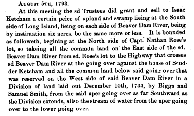
In 1792, they sell a piece of property 10 rods long [165 feet] to Isaac Ketcham for 16 shillings:

Then in 1793, they sold Isaac Ketcham land on both sides of Beaver Dam River. The upper going-over appears to have been in a direction toward Scudder Ketcham’s house. Isaac Ketcham is believed to have been Scudder’s father, but it is not known where in Fire Place the father lived. Scudder Ketcham died five years after this land purchase by his father at the age of 37.

In 1808, the Commissioners of Highways, when petitioned by Robert and Charles Ellison, met and judged the road laid out on the west side of Beaver Dam River “to be intirely useless and unnecessary to accommodate the Public,” and had it stopped up from the head of the river or swamp on the west side to the lower going over.
They then laid out a new 4-rod-wide road “from the head of the ottor Swamp Northeasterly as it now Runs Crossing the Beaver Dam River at a place called the upper going Over.” I’m not sure where the head of Otter Swamp was. I think “Otter Swamp” was that valley west of the Adult Home on Beaver Dam Road.
In February 1813, they reduced the width of a northern section of the road on the east side of Beaver Dam River from six rods wide to four rods wide: “from the going over at Mrs. Ketchams Northward to the head of the Beaver dam swamp” leaving the Common Land on the West side of sd Road.”
After having narrowed the road, the Trustees sold off an acre of land to Benjamin Brown for $50 on 2 Mar 1813. I think the dimensions would be similar to that shown at right. The upper going over was not as wide as it is today and continued more directly to the east. The description of the one acre starts at the southeast corner:
Beginning at the Southeast Corner at a certain Stake Set up about three Rods to the Northward of the going over against Mr. Ketcham’s House from then Runing Southwest to a Certain Maple Bush Marked in the swamp from thence Runing Northward by the Bank or River about twenty Rods [330 feet] to Certain Bounds fixed from thence runing Eastward to the Road and thence Southward by the Road as the Road has lately been fixed and altered to the aforementioned Bound leaving a Road four Rods Wide which sd piece of Land Contains about one Acre More or less.
The land bounded by Beaver Dam River on the west and the road that ran north-to-south on the east was not a part of the original land divisions. It was common land, and was sold by the Town to individuals long after the original divisions of the land at the South. So even though Richard Corwin owned some of the land east of the road, he probably would not have originally owned any of the land west of the road.
In fact, in 1818 and 1819, John Rose Esq. appears to have purchased the land originally sold to Benjamin Brown. Then John Rose and Dr. Nathaniel Miller together buy up the rest of the unsold common land. However, in order to figure out the boundaries of the the common land contained in these 1818 and 1819 purchases, I need to find out where “Alexander Hawkins” house was located and where “Elizabeth Ellison” lived.
The 1818 purchase says that the land being sold to John Rose is bounded east by the highway, South by the land of Doctor Nathaniel Miller, West by the Beaver Dam River, and North “to a certain Bound to be set so as to range with the south part of Richard Corwins Milk house.”
I think the phrase “so as to range with” means that the northern boundary of John Rose’s property is being established by the location of the “south part” of Richard Corwin’s milk house on the other side of the road (east side).
So, unless Richard Corwin increased his land holdings by purchasing a plot across the road, he would not have had land west of the highway on which to build the Lecture Room in 1842.
I may be able to find a deed for Robert Ellison’s purchase of the land where the store was located, which would probably note the location of the Lecture Room if it was already erected when he made his purchase and if it was located on the west side of the road at that time.
Richard