
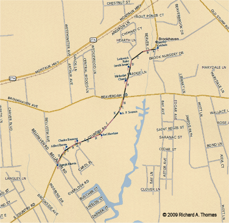
On page 99 of the Records of the Town of Brookhaven, 1856-1885 is recorded a “survey of a three rod public road from the land of Sam’l Carman at Squawsucks, across Fireplace Neck to Beaver Dam lower crossing — Magnetic course.” This road was Beaverdam Rd., and its right-of-way was 49.5 feet (3 rods)./
This survey is useful as it indicates some of the residences on the road at that time, and their exact locations. The table below records the actual surveyor’s dimensions and the map below is scaled from these dimensions. N. Miller, Jr. was the Surveyor. The survey was apparently conducted 20 July 1858.
It is interesting to compare this survey with the 1858 Chace map. The house labeled J. Carman on the Chace map was the most easterly house on Beaverdam Rd., located on the banks of the Carman’s River. The Town survey starts at a house belonging to Moses Swezey (which I have yet to identify). Beaver Dam Road as a Town road apparently ended at Samuel Carman’s western property line (the property apparently being owned by Joseph Carman’s father); the road from there to the river was a private road. At the western end of the survey, Ephraim Pease was recorded as having had a house between Charles Swezey and Beaver Dam Creek; no house was indicated on the Chace map. The Charles Swezey house was located at the northeast corner of Beaver Dam Rd. and Fire Place Neck Rd.
The road’s point of beginning is “south thirty seven and a half degrees east one chain & twelve links” from the southeast corner of Moses Swezeys house. A surveyor’s “chain” is 66 feet (or 4 rods); each chain contains 100 links (7.92 inches). Each “survey section” is labeled on the map.

| Survey Section | Direction | Chains | Links | Distances |
| 1 – Southeast corner Moses Swezey house |
South 37½° East | 1 | 12 | 73.92 feet |
| A – Start | South 86½° West | 10 | 49 | 706.2 feet |
| B | North 74° West | 0 | 21 | |
| 2 – Southwest corner J. S. Rose house [Historic Structure ID Br17.1-S] |
South | 0 | 60 | 39.6 feet |
| C | North 83½° West | 3 | 37 | 325.38 feet |
| D | North 79½° West | 1 | 56 | |
| 3 – Southwest corner Wm. B. Rose house [Historic Structure Br17A] |
South 26° West | 0 | 80½ | 58.41 feet |
| E | North 78½° West | 5 | 15 | 1232.88 feet |
| F | North 76° West | 13 | 53 | |
| 4 – Southwest corner Selah Hawkins house [Historic Structure ID Br20] |
South 15° West | 0 | 91 | 60.06 feet |
| G | North 76° West | 4 | 47 | 700.92 feet |
| H | North 78° West | 2 | 85 | |
| I | North 89° West | 3 | 30 | |
| 5 – Southwest corner Dan’l Hawkins House [Historic Structure ID Br24B] |
South 38° West | 0 | 89 | 58.74 feet |
| J | North 79½° West | 4 | 10 | 1174.8 feet |
| K | North 74° West | 6 | 15 | |
| L | North 80½° West | 7 | 55 | |
| 6 – Southwest corner Charles Swezey house [Historic Structure ID Br27A.1-S] |
South 30° West | 0 | 77 | 50.82 feet |
| M | North 86° West | 0 | 90 | 409.2 feet |
| N | South 86° West | 5 | 30 | |
| 7 – Southwest corner Ephraim Pease house |
South 31° West | 1 | 52 | 100.32 feet |
| O – End Beaverdam Brook |
North 86° West | 5 | 44 | 359.04 feet |
| Total Distance: |
4908.42 feet | |||