2. Residential zoning: upzoning efforts with the Town
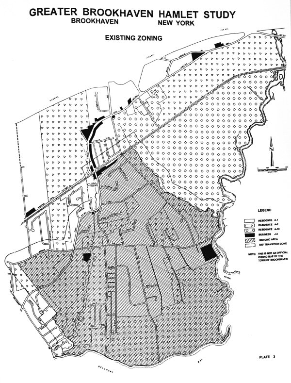
Ever since Brookhaven Town released its 1987 Land Use Plan, the Zoning & Development Committee, the forerunner to the BVA’s current Land Use Committee, worked to have the whole Hamlet upzoned. The committee’s request was for all publicly held lands to be upzoned to A10, all lands along stream corridors to be AS, and the rest of the Hamlet to be A2. See Plate 3.
After several years of working with Town Planning officials and aided by a 1990 Long Island Regional Planning Board study of the Beaver Dam Creek, in July of 1991 the following 436.23 acres were upzoned by the Town Board, (They are listed in the same block format the town used to make its determination. All areas were upzoned from Al to A2 unless otherwise noted):
1.) 9.2 acres of NYSDEC land east of the end of Bay road (north of the three houses on Ocean Place), to A10, (Resolution DD-47)
2.) A 13.8-acre tract, east of Old Town Road, just south of Sunrise Highway, in the headwaters of the Beaver Dam Creek. (Resolution DD-81)
3.) All 183.65 acres in the headwaters of the Beaver Dam Creek, bordered on the north by Sunrise Highway, on the east by Old Town Road, on the south by Montauk Highway and on the west by Carnegie Avenue ( a “paper street”). This block affected about 50 different property owners, The majority of land is owned by State, County, or Town government and about 20 acres by the Brookhaven Fire Department. The only person living within this block is Mrs. Waldron, who said that she did not oppose the upzoning. (Resolution DD-82)
4.) All 45.1 acres of the Bellport High School. (Resolution DD-83)
5.) 13.1 acres, belonging to Nash, McCutcheon, Tooker and the Post Morrow Foundation, north of the Beaver Dam Road bridge on the creek. (Resolution DD-84)
6.) All 12.2 acres of the Brookhaven Elementary School on Fire Place Neck Road. (Resolution DD-85)
7.) 33.7 acres owned by Puleston, Clement and Barry, located mostly north of Locust. (Resolution DD-86)
8.) 74.2 acres, about 80% of the land starting at the Old South Haven Church, bordered by South Country Road and Beaver Dam Road, west to and including the Marist Brothers property. (Resolution DD-87)
9.) 3 acres of NYSDEC land at the end of Bellhaven Road, to A10. (Resolution DD- 88)
10.) 9.6 acres along Chapel Avenue, belonging mostly to former BVA president Al Hotchkin. Hotchkin spoke at the public hearing complaining that upzoning should not be spot but rather Hamlet-wide. (Resolution DD-90)
11.) 30.88 acres at the west end of Bay Road half belonging to the town (formally Saltaire) and half to NYSDEC, to A10. (Resolution DD-93)
12.) 20 acres on Burnett Lane, referred to as “Historic Brookhaven,” owned by Nancy Lee of Bellport. (Resolution DD94)
Hamlets Study
- i-iii Prologue
- Table of Contents
- 1 I. Introduction
- 1 a Plate 1
- 2-4 II. Overview
- 5-8 II. Overview
- 9-11 III. History
- 12 IV. Land Use
- 12 a Plate 2
- 13-14 IV. Land Use
- 15 IV. Land Use
- 15 a Plate 4
- 15 b Carman’s River
- 16 V. Land Use Issues
- 17 V. Land Use Issues
- 18 V. Land Use Issues
- 19 V. Land Use Issues
- 20 V. Land Use Issues
- 20 a Plate 5
- 21-22 VI. Other Issues
- 23-24 VI. Other Issues
- 25 VI. Other Issues
- 25 a Plate 6
- 26-27 VI Other Issues
- 28-29 VI Other Issues
- 30-31 VII Summary
- 32 VII. Recommendations
- 33 VII. Recommendations
- 34 VII. Recommendations
- 35-39 A. Questionnaire
- 40-42 B. Community Comments
- Zoning
While we appreciate the Town’s efforts for the above 1991 upzoning, we still do not understand why the Town decided to do spot upzoning rather than a blanket upzoning of the whole Hamlet since it lies entirely within the Town-defined Critical Environmental Area. It should be noted that, despite all the landowners involved in the above upzoning, there was no opposition from anyone, only support at the public hearing. Several times since the 1991 upzoning, the BVA has reiterated its request to the Department of Planning, to no avail, to have all remaining parcels two acres and larger in the South Shore Critical Environmental Area upzoned to A2.
3. Preserved land in hands of Town, County, State and Federal Governments
Despite the loss of the Post Point Farm to development, during this past decade, there have been many positive accomplishments for our community, including the following:
- County purchased the Robinson Duck Farm.
- Town purchased the 18-acre former Saltaire property.
- Former Saltaire Property became the Fire Place Nature Preserve.
- 440-acres within the Hamlet were upzoned.
- County acquired the former Hawes Property.
- Former Hawes Property became the Dennis Puleston Nature Preserve.
- Post Morrow Foundation announced intent to preserve Beaver Dam Creek.
- NYS legislature enacted BVA idea – the South Shore Estuary Reserve Act.

